Showing posts with label Haida Gwaii. Show all posts

Sunday, March 10, 2013

ShipPlotter: No Coast Guard? You too can Monitor Oil tanker traffic in Douglas Channel

Conversations over a Sunday morning Breakfast/Brunch at Burnaby's James Street Cafe and Grill covers many a topic.... from Morse Code to ... Semaphore (if Christy is looking for another way to skirt her Office's requirement according to the LAW which prohibits the shredding, deleting, burning of emails, documents, calendars, videos, notes, reports, etc..... MEMOs)  to Digital Decoders and eventually to digital decoder ship locations in Real Time.

For good measure we talked, He talked (same fellow) who came up with the Nelson "Galvania" Skalbania Post idea for the BlogBorgCollective ..... (Galvania's) using iron filings to "fertilize" the waters surrounding the Islands of Galapagos and Haida Gwaii.... DUMB move on the part of Planktos Corp., dumping 45 tons of the iron into the Galapagos, without consulting Marine scientists........ and then repeated their performance without informing the Federal Government of Canada.  Especially in light .... sunlight extremes between the two Islands.... Galapagos Island on the Equator.... with two seasons, SUMMER, and Haida Gwaii with two seasons WINTER.  


Mustn't forget to mention the other topic....keywords being:  Graph(ite) Accumulators... new technology.... with Toyota-like-Prius comes to mind because when that car's batteries goes DEAD, and they do, the price tag to replace the batteries is close to $4,000, and then there are the fees to dispose of them (the batteries)(extra).  Same holds true for the solar panels to assist the Province in creating access to BC Hydro's Net Metering (Smart Meter) system, whereby YOU, the homeowner, becomes an Independent Power Producer...... The problem lies not so much of the idea of having solar panels, typically on the roof of your abode, but more so with the storage of the accumulated energy.... the battery silos,  ..... like the Prius', need to be replaced.    The expected money"saved", is lost to maintenance charges.


ShipAIS


ShipAIS and "Ship Plotter" are two programs (hardware required too) looks like the perfect devices to track tankers and other resource transportation vessels like those two puny tugs that Enbridge is supposed to be tagging, afore and astern, on the mammoth tanker vessels for the Northern Gateway Douglas Channel run between Kitimat and the Open waters of the Pacific Ocean. ..... to and fro.    The system would also open a new hobby, one that complements HAM operators and chasers of Police and Emergencies, with Scanners that currently exist......

 Ship Plotter

.......The AIS system faithfully reported all the ship, tug, and ferry traffic and since it was a clear day, it was easy to relate the display to the real world. All the shipping info and positions seemed to be very accurate. In fact, a tug was returning from berthing a ship and as I approached Oakland outer harbor from the opposite side of the container pier, I noticed the tug being plotted on ShipPlotter on the other side. I couldn't see the tug since it was on the other side of the pier but knew it was there and took action to avoid the tug as we both "popped" out at the end of the pier.

Sailing the Bay (San Francisco) on Sunday was easier as well especially with ShipPlotter accurately showing course & speed for the high speed ferry traffic (30 - 35 knots) coming south from Vallejo, CA.

As far as performance, ShipPlotter was plotting shipping as far out as 25 nm. Much farther than the radar. But, when the radar did detect a ship, it was easy to identify and track. .......
 Communities along the shores, between Prince Ruper and Hartley Bay, could use the software, and hardware, to supplement the non-existent Coast Guard vessels which were sent to Newfoundland's treacherous Green Water coastline, complete with Icebergs.

UPDATE:  Anonymous 6:00pm recommends..... http://www.marinetraffic.com/ais/   And it's certainly impressive!!!!  And... if you look from on high you can see the overall ship traffic going in, and out of the Port of Vancouver.... and then THINK about the marine traffic that is being proposed to go into Kitimat........


 There is one other source, the need to track up to date, real-time weather forecasts....real time???  HF Weather Fax Marine Radio


Sunday, October 28, 2012

Has Nelson "Galvania" iron fertilization off Haida Gwaii broken the "padlocks" on the tetonic plates of the Pacific North West?

"Did the ocean iron fertilization in Haida Gwaii islands a couple of weeks ago, cause the earthquake  yesterday?   Just a thought."     - From a BBC concerned citizen
~~~~~~~~~~~~~~~~~~~~~~~
UPDATE: September 4, 2013   Oceanus Magazine:


Will Ocean Iron Fertilization Work?
Getting carbon into the ocean is one thing. Keeping it there is another.
AND

~~~~~~~~~~~~~~~~~~~

As tectonic plates go, the Pacific one is slowly slipping beneath the North America plate.

What holds them together are the "padlocks" of lithosphere, which has a higher strength and lower density than the underlying asthenosphere.

Iron fertilization, with Nelson Skalbania's involvement, has "rusted" those "padlocks".


How Iron fertilization is suppose to work:

Wikipedia: "Iron is a trace element necessary for photosynthesis in all plants."

If you've forgotten about photosynthesis:  

"....Photosynthesis is a process used by plants and other organisms to convert the light energy captured from the sun into chemical energy that can be used to fuel the organism's activities. ..."


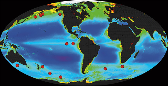
In 2007, Planktos Corp. tossed 45 tons of iron filings overboard near the Galapagos Islands:

Planktos Corp. has made headlines in newspapers around the globe, including the New York Times and the Daily Telegraph, on account of its plan to toss 45 tons of iron filings into the South Pacific Ocean near the Galapagos Islands. The theory is that this will stimulate plankton growth, which will promote the absorption of carbon dioxide and impede global warming.

The idea, the Times noted, is similar to planting forests full of carbon-inhaling trees, which is what Planktos is also doing in Hungary.

So how will Planktos make money from these ventures?

In both projects, environmentally conscious corporations and individuals will have the opportunity to offset the carbon dioxide they emit by paying Planktos a few dollars for every ton of carbon dioxide their projects absorb from the atmosphere. - The Vancouver Sun June 23, 2007  

You may be about to laugh at our logic here at the BBC, but to hear a proponent say that the process of  photosynthesis turned the tide to favour "Galvania" theorists near the Galapagos Island, therefore it will work off of Haida Gwaii as well, ..... isn't quite true when it comes to the god called "Sunlight".

Galapagos Islands Temperatures range from 69°-84°F / 21°-30°C
 People living on the Equator, experience only Two Seasons.

Haida Gwaii  Temperature range   32°-64.4°F  /  0°-18°C
 Haida Gwaii has .... Four Seasons
***********************
*************

Key Points to Understand

• Slanted light does not heat objects as quickly as direct light.

• Because the Earth is nearly round, the equator receives direct light, and the poles receive slanted light, with a gradation in between.

• Due to the differential heating of the Earth’s surface (unequal heating of all regions), it is always warmer at the equator than at the poles.

Background Information

Temperatures at the equator are, on average, the hottest on the planet. It is a common misunderstanding that it is hotter at the equator because the equator is closer to the sun. Its location at the center of the Earth is what makes its average temperature warmer than any other place on Earth, because the equator always receives direct sunlight, whether it is summer or winter. Because of the Earth’s spherical shape, sunlight hits the equator directly year-round, unlike the North and South Poles. ........

Source:  Grade 6 to 8


~~~~~~~~~~~~~~~~~~~~~


Daylight to Night, Summer to Fall and back to Summer,at the Equator (Galapagos), is an almost even split of 12 hours on, 12 hours off

Daylight to Night, at Haida Gwaii, in the Winter .... :

Being as far north as we are (above 54 deg N), the Winter daylight is very short with the Sun (if we see it at all) after 8:30AM local, and Setting shortly after 3:00 PM. The sun doesn't Rise more than about 20 degrees above the horizon.   Six and half Hours!
..... the middle of summer, the Sun rises before 5:00am with Sunset not until after 10:00pm.  Seventeen Hours!  DX-er.ca     DX is ham radio shorthand for "distance"


There are some similarities between Haida Gwaii and the Galapagos:


The diverse geography and landscape of the Islands is reflected in its biological diversity. There are a large number of plant and animal species and sub-species that are only found on the archipelago. This is one reason why the Islands are often referred to as “the Galapagos of the North.”