Showing posts with label Enbridge. Show all posts

Wednesday, January 21, 2015

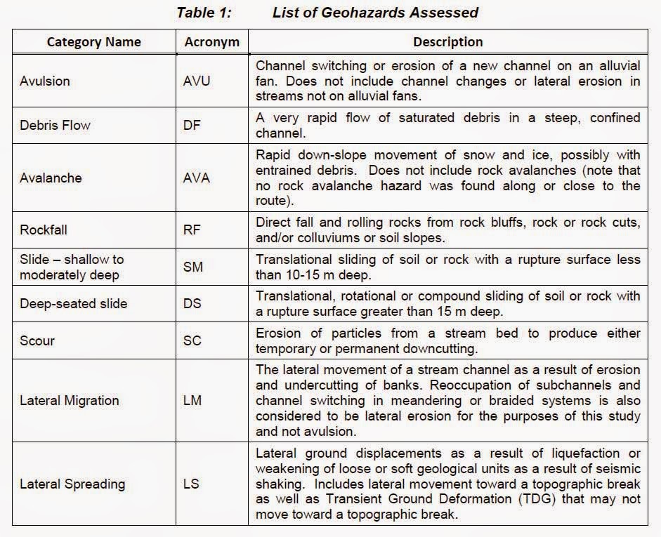
Enbridge Northern Gateway 'Discrete Geohazards' outnumber Kinder Morgan Trans Mountain Pipeline ...but

.... but that doesn't mean Kinder Morgan Trans Mountain 'Discrete Geohazards' aka 'Anomaly' or 'Anomalies' pipelines are safer than Enbridge Northern Gateway pipeline.

Enbridge GeoHazard List is longer, much longer in detail than  Kinder Morgan.  Has KM skimped on the details and then claiming immunity .... for reasons of security?  Actually KM only provides the Ten Highest GeoHazards, their number may be much higher than Enbridge's 363 Geohazards.

American Society of Mechanincal Engineers  (ASME): 

Pipeline Integrity Analyses for Construction in Mountainous Areas

ratcheting
Exacerbated by complex routing and profile, pipelines constructed in mountainous areas are at risk to develop significant uplift in the soil at bend locations during hydrostatic testing and initial operating cycles. If such uplift displacement accumulates during subsequent operating cycles, a phenomenon known as ratcheting, the pipe may eventually fail by upheaval buckling. 


 http://proceedings.asmedigitalcollection.asme.org/proceeding.aspx?articleid=2022505


****************

Page 97


One
Two


Three

Four

Five

Six

Seven

Eight

Nine

Ten

Eleven
Twelve

 363 Geohazards

Hoult Creek and Upper Kitimat Valley appear to be the most 'difficult' sections for Enbridge

***************************

Kinder Morgan Trans Mountain 


Page 24

ONE


TWO

THREE

Sunday, March 10, 2013

ShipPlotter: No Coast Guard? You too can Monitor Oil tanker traffic in Douglas Channel

Conversations over a Sunday morning Breakfast/Brunch at Burnaby's James Street Cafe and Grill covers many a topic.... from Morse Code to ... Semaphore (if Christy is looking for another way to skirt her Office's requirement according to the LAW which prohibits the shredding, deleting, burning of emails, documents, calendars, videos, notes, reports, etc..... MEMOs)  to Digital Decoders and eventually to digital decoder ship locations in Real Time.

For good measure we talked, He talked (same fellow) who came up with the Nelson "Galvania" Skalbania Post idea for the BlogBorgCollective ..... (Galvania's) using iron filings to "fertilize" the waters surrounding the Islands of Galapagos and Haida Gwaii.... DUMB move on the part of Planktos Corp., dumping 45 tons of the iron into the Galapagos, without consulting Marine scientists........ and then repeated their performance without informing the Federal Government of Canada.  Especially in light .... sunlight extremes between the two Islands.... Galapagos Island on the Equator.... with two seasons, SUMMER, and Haida Gwaii with two seasons WINTER.  


Mustn't forget to mention the other topic....keywords being:  Graph(ite) Accumulators... new technology.... with Toyota-like-Prius comes to mind because when that car's batteries goes DEAD, and they do, the price tag to replace the batteries is close to $4,000, and then there are the fees to dispose of them (the batteries)(extra).  Same holds true for the solar panels to assist the Province in creating access to BC Hydro's Net Metering (Smart Meter) system, whereby YOU, the homeowner, becomes an Independent Power Producer...... The problem lies not so much of the idea of having solar panels, typically on the roof of your abode, but more so with the storage of the accumulated energy.... the battery silos,  ..... like the Prius', need to be replaced.    The expected money"saved", is lost to maintenance charges.


ShipAIS


ShipAIS and "Ship Plotter" are two programs (hardware required too) looks like the perfect devices to track tankers and other resource transportation vessels like those two puny tugs that Enbridge is supposed to be tagging, afore and astern, on the mammoth tanker vessels for the Northern Gateway Douglas Channel run between Kitimat and the Open waters of the Pacific Ocean. ..... to and fro.    The system would also open a new hobby, one that complements HAM operators and chasers of Police and Emergencies, with Scanners that currently exist......

 Ship Plotter

.......The AIS system faithfully reported all the ship, tug, and ferry traffic and since it was a clear day, it was easy to relate the display to the real world. All the shipping info and positions seemed to be very accurate. In fact, a tug was returning from berthing a ship and as I approached Oakland outer harbor from the opposite side of the container pier, I noticed the tug being plotted on ShipPlotter on the other side. I couldn't see the tug since it was on the other side of the pier but knew it was there and took action to avoid the tug as we both "popped" out at the end of the pier.

Sailing the Bay (San Francisco) on Sunday was easier as well especially with ShipPlotter accurately showing course & speed for the high speed ferry traffic (30 - 35 knots) coming south from Vallejo, CA.

As far as performance, ShipPlotter was plotting shipping as far out as 25 nm. Much farther than the radar. But, when the radar did detect a ship, it was easy to identify and track. .......
 Communities along the shores, between Prince Ruper and Hartley Bay, could use the software, and hardware, to supplement the non-existent Coast Guard vessels which were sent to Newfoundland's treacherous Green Water coastline, complete with Icebergs.

UPDATE:  Anonymous 6:00pm recommends..... http://www.marinetraffic.com/ais/   And it's certainly impressive!!!!  And... if you look from on high you can see the overall ship traffic going in, and out of the Port of Vancouver.... and then THINK about the marine traffic that is being proposed to go into Kitimat........


 There is one other source, the need to track up to date, real-time weather forecasts....real time???  HF Weather Fax Marine Radio


Tuesday, February 5, 2013

Petroglyphs at waters edge, Threatened with Oil

Oil from Alberta;

Liquid Natural Gas from British Columbia...

......... leaving the Ports of  Prince Rupert (which has had three groundings of freighters in late 2012)  AND Kitimat.   The latter is expecting 10 major projects to get underway within a year.

There's been plenty of concerns raised with Enbridge's Northern Gateway Pipeline, from Watershed destruction, to fisheries, to the removal of 1,000 square kilometres of islands in way of Douglas Channel.  The Captains of industry will stop at nothing to gain riches.

Ecological Reserves....  are in Harms Way, so too is this:

Google Search Criteria    Alaska petroglyphs, Babbler Creek, Sitka


The rock art of the Northwest Coast. - Summit - Simon Fraser ...

summit.sfu.ca/system/files/iritems1/4415/b13752807.pdf
File Format: PDF/Adobe Acrobat
by DM Lundy - 1974
This thesis examines Indian petroglyphs and pictographs (carvings and ... of Alaska south to the Dalles of the Columbia River. ..... At Katlian Bay, (in the mouth of the bay) north of. Sitka. Kennedy 1974. At the village of Sitka, in Kalinin ... Reported located at Craig Boat Harbour, Kennedy 1974. .... Located on Babbler Point.

************************************************

These images, like most on the shores of Alaska and British Columbia, are at the water's edge... reached by canoes, originally..... power boats today, Oil and LNG tankers tomorrows.


Thursday, January 17, 2013

Pete McMartin Locked-Down 'Public" pipeline hearings begone

All that Pete McMartin needs to do to put "grace" in charge, instead of disgrace into the pipeline hearings, is to have an outspoken, but the firm steady voice that the Vancouver Police Department and the RCMP alike, know, and jump to attention when spoken to.   And for good measure that other law enforcement agency, Sheriffs.

The one "force" with "grace" belongs to B.C. Supreme Court Chief Justice Robert Bauman.  The only security forces being left out thus far from the Chief Justice attention is the "Media security forces" ushering speakers to their places, and out, in what is supposed to be an Open and Transparent Public hearing.

....When I attended, security was heavy and very, very evident.  There was a police wagon parked outside the hotel, with cops in the hotel lobby and on the fourth floor.  I counted nine of them.  They were there, I'm sure, to prevent a repeat of Tuesday's incident, when ........... Pete McMartin
As to the Chief Justice's handling of the decorum in his Court House......

"That is not the profile the courthouse(s) should project. It should reflect openness - a calm and reflective atmosphere in which critical judicial proceedings can proceed impartially and where the public is free so far as is reasonable to come and go and witness the proceedings unfold."  Kim Bolan, Vancouver Sun

Wednesday, November 7, 2012

Retard assists Oil tankers in Puget Sound page 21

"Retard Assist" aka "Retard Maneuver", calls for Tugs to slow down large vessels by trying to divert them, rather than STOP.   See link at bottom.

No one is suggesting that Enbridge's oil tankers, carting Alberta's petroleum resources to foreign ports of call, should be denied by a fellow province.... accept by Premier Christy Clark.   No one is suggesting that these huge oil tankers will be making a U-Turn in Douglas and Principe Channels, nor is there a suggestion that they will be running these ships at open Pacific Ocean speed.

Many, actually all of the images that Enbridge has produced for public consumption, show our British Columbian waters as idyllic (extremely happy, peaceful, or picturesque).

Enbridge promises that there will be two tugs assisting the tanker(s) from the Pacific Ocean to Kitimat empty, save for ballast..... and again from Kitimat to the open Pacific Ocean, fully loaded with sand laden with oil.

One tug, as depicted in the cartoon below is to the Port of the slow moving tanker.  The second tug is Astern of the tanker and that tug  is reversing the whole distance from the Pacific to Kitimat and back again.... under idyllic coastal water conditions.  We know the Astern tug is in reverse because the sharp pointy end of a boat, the Bow is going in the opposite direction as the vessel that it's tied to.    The blunt end is called the Stern and it's facing the Stern of the oil tanker.  This method, that Enbridge has displayed in their artist rendering, this Cartoon, below, is a sure-fire way to send many a good seamen to their watery graves.  The steel hulled Tug, NOT DOUBLE HULLED, will reach the bottom of either of the two channels, before you can utter.... Holy-cow.  Plus if there is a rescue attempt made, it will be akin to the demise of the Atlantic Convoy stragglers.  The "other" tug, in this case, couldn't leave their charge, the massive oil tanker, alone in treacherous waters!


Because of their huge mass, tankers have a large inertia, making them very difficult to steer. A loaded supertanker could take as much as 4 to 8 kilometers and 15 minutes to come to a full stop and has a turning diameter of about 2 kilometers.


EVEN the tugs, will have Quieter Engines
The only way in which Oil tankers and the assisting tugs could have Quieter engines is if they were to use Lithium created energy for propulsion like that of Foss Hybrid Tug.


Here in Vancouver, Canada, ships entering our Harbour have two THREE tugs, Two at the Stern of the oil tanker, facing the same direction as the larger vessel's direction.... Third tug at the fore.

Everest Spirit


 And if you missed the headline August 23, 2012, Globe and Mail:

"The ship currently docked at Kitimat looking like a prizefighter with a broken nose is an ugly reminder of the threat posed by proposed pipelines and tanker traffic to the territory of the Gitga'at First Nation," said the statement issued by the band, which is based in Hartley Bay, on Douglas Channel.
Last but not the Least, of importance is this handy-dandy booklet that we found by using this search criteria in Google:    how powerful has a tug got to be to stop an oil tanker


Retard Assist Page 21 of 154
--------------------------------------------------

Something else you should be looking at, is the speed of an Oil Tanker out in open Pacific Ocean:

12 knots = 13.8094 mph = 22.224 km/h

To put this all in perspective, British Columbians have heard about the BC Ferry system which run  out of Horseshoe Bay and over to Departure Bay is 23 knots pushing 10,034 tonnes along.....  those Oil tankers, the ones plying to and fro our coastal waters,  like a Suezmax Tanker,  Loaded, to 125,000 dwt is TWELVE times larger, in weight, than a BC Ferry... built in Germany.
Enbridges says in their "cartoon" up top that "tankers travel slowly but the speed will be reduced".
The speed of the Tanker isn't the problem here, it's the stopping, or Retarding capabilities like this vessel travelling at 12 knots (Pages 57, 58, 59 of 154):  854.3 feet long etc

"Retarding Maneuver",  NOT stopping,  means that this particular vessel, with Rudder problems, will travel 6,000 feet forward, and another 6,000 feet to Starboard.... but on the diagonal..... Hmmmm where did we leave our Grade 8 Math of  Pythagoras Theorem?  


C = 8,485.28 Feet

Thursday, September 27, 2012

How many Ecological Reserves can Enbridge, and other like minded Energy corporations, destroy just to make a buck or two?


In some ways, Ecological Reserves are a tad more precious that our Pristine west coast.

Things to Do and See  BC Parks via the oil Tanker Route


Hmmmm Groundwater cover Thermal Springs too....    Click on Groundwater then search for Thermal Spings ...in Chapter 7


The first Ecological Reserves as of May 1971


Current batch of Ecological Reserves, 153, all told

1 Aleza Lake Ecological Reserve
2 Ambrose Lake Ecological Reserve
3 Anne Vallee (Triangle Island) Ecological Reserve This ecological reserve is closed to the public.
4 Atlatzi River Ecological Reserve has been renamed to Kingcome River/Atlatzi River Ecological Reserve
5 Baeria Rocks Ecological Reserve This ecological reserve is closed to the public.
6 Ballingall Islets Ecological Reserve This ecological reserve is subject to special restrictions.
7 Baynes Island Ecological Reserve
8 Bednesti Lake Ecological Reserve
9 Beresford Island Ecological Reserve This ecological reserve is closed to the public.
10 Big Creek Ecological Reserve
11 Big White Mountain Ecological Reserve
12 Blackwater Creek Ecological Reserve
13 Blue/Dease Rivers Ecological Reserve
14 Bowen Island Ecological Reserve
15 Bowser Ecological Reserve
16 Brackman Island Ecological Reserve
17 Browne Lake Ecological Reserve
18 Buck Hills Road Ecological Reserve
19 Burnt Cabin Bog Ecological Reserve
20 Byers/Conroy/Harvey/Sinnett Islands Ecological Reserve
21 Campbell Brown (Kalamalka Lake) Ecological Reserve
22 Canoe Islets Ecological Reserve This ecological reserve is closed to the public.
23 Cardiff Mountain Ecological Reserve
24 Catherine Creek Ecological Reserve
25 Cecil Lake Ecological Reserve
26 Charlie Cole Creek Ecological Reserve
27 Chasm Ecological Reserve
28 Checleset Bay Ecological Reserve
29 Chickens Neck Mountain Ecological Reserve
30 Chilako River Ecological Reserve
31 Chilliwack River Ecological Reserve
32 Chunamon Creek Ecological Reserve
33 Cinema Bog Ecological Reserve
34 Clanninick Creek Ecological Reserve
35 Claud Elliott Creek Ecological Reserve
36 Clayhurst Ecological Reserve
37 Cleland Island Ecological Reserve This ecological reserve is closed to the public.
38 Columbia Lake Ecological Reserve
39 Comox Lake Bluffs Ecological Reserve
40 Cougar Canyon Ecological Reserve
41 Det San Ecological Reserve
42 Dewdney and Glide Islands Ecological Reserve This ecological reserve is closed to the public.
43 Doc English Bluff Ecological Reserve
44 Drizzle Lake Ecological Reserve
45 Drywilliam Lake Ecological Reserve
46 Duke of Edinburgh (Pine/Storm/Tree Islands) Ecological Reserve This ecological reserve is subject to special restrictions.
47 East Redonda Island Ecological Reserve
48 Ellis Island Ecological Reserve
49 Evans Lake Ecological Reserve
50 Field's Lease Ecological Reserve
51 Fort Nelson River Ecological Reserve
52 Francis Point Ecological Reserve This ecological reserve is subject to special restrictions.
53 Fraser River Ecological Reserve
54 Galiano Island Ecological Reserve
55 Gamble Creek Ecological Reserve
56 Gilnockie Creek Ecological Reserve
57 Gingietl Creek Ecological Reserve
58 Gladys Lake Ecological Reserve
59 Goosegrass Creek Ecological Reserve
60 Grayling River Hot Springs Ecological Reserve
61 Haley Lake Ecological Reserve
62 Haynes' Lease Ecological Reserve
63 Heather Lake Ecological Reserve
64 Honeymoon Bay Ecological Reserve
65 Hudson Rocks Ecological Reserve This ecological reserve is subject to special restrictions.
66 Ilgachuz Range Ecological Reserve
67 Katherine Tye (Vedder Crossing) Ecological Reserve
68 Kingcome River/Atlatzi River Ecological Reserve
69 Kingfisher Creek Ecological Reserve
70 Klanawa River Ecological Reserve
71 Klaskish River Ecological Reserve
72 Kotcho Lake Ecological Reserve This ecological reserve is subject to special restrictions.
73 Ladysmith Bog Ecological Reserve has been renamed to Yellowpoint Bog Ecological Reserve
74 Lasqueti Island Ecological Reserve
75 Lepas Bay Ecological Reserve This ecological reserve is subject to special restrictions.
76 Lew Creek Ecological Reserve
77 Lily Pad Lake Ecological Reserve
78 Liumchem Ecological Reserve
79 Mackinnon Esker Ecological Reserve
80 Mahoney Lake Ecological Reserve
81 Mara Meadows Ecological Reserve This ecological reserve is closed to the public.
82 McQueen Creek Ecological Reserve
83 Megin River Ecological Reserve
84 Meridian Road (Vanderhoof) Ecological Reserve
85 Misty Lake Ecological Reserve
86 Moore/McKenney/Whitmore Islands Ecological Reserve This ecological reserve is closed to the public.
87 Morice River Ecological Reserve
88 Mount Derby Ecological Reserve
89 Mount Elliott Ecological Reserve
90 Mount Griffin Ecological Reserve
91 Mount Maxwell Ecological Reserve
92 Mount Sabine Ecological Reserve
93 Mount Tinsdale Ecological Reserve
94 Mount Tuam Ecological Reserve
95 Mount Tzuhalem Ecological Reserve
96 Narcosli Lake Ecological Reserve
97 Nechako River Ecological Reserve
98 Nimpkish River Ecological Reserve
99 Ningunsaw River Ecological Reserve
100 Nitinat Lake Ecological Reserve
101 Oak Bay Islands Ecological Reserve
102 Ospika Cones Ecological Reserve
103 Parker Lake Ecological Reserve
104 Patsuk Creek Ecological Reserve
105 Pitt Polder Ecological Reserve
106 Portage Brule Rapids Ecological Reserve
107 Race Rocks Ecological Reserve This ecological reserve is subject to special restrictions.
108 Ram Creek Ecological Reserve
109 Raspberry Harbour Ecological Reserve
110 Robson Bight (Michael Bigg) Ecological Reserve
111 Rolla Canyon Ecological Reserve
112 Rose Islets Ecological Reserve This ecological reserve is closed to the public.
113 Rose Spit Ecological Reserve
114 Ross Lake Ecological Reserve
115 San Juan Ridge Ecological Reserve
116 San Juan River Estuary Ecological Reserve
117 Sartine Island Ecological Reserve This ecological reserve is closed to the public.
118 Satellite Channel Ecological Reserve
119 Saturna Island Ecological Reserve
120 Sikanni Chief River Ecological Reserve
121 Skagit River Cottonwoods Ecological Reserve
122 Skagit River Forest Ecological Reserve
123 Skagit River Rhododendrons Ecological Reserve
124 Skeena River Ecological Reserve
125 Skihist Ecological Reserve
126 Skwaha Lake Ecological Reserve
127 Smith River Ecological Reserve
128 Soap Lake Ecological Reserve
129 Solander Island Ecological Reserve This ecological reserve is closed to the public.
130 Stoyoma Creek Ecological Reserve
131 Sunbeam Creek Ecological Reserve
132 Sutton Pass Ecological Reserve
133 Tacheeda Lakes Ecological Reserve
134 Tahsish River Ecological Reserve
135 Takla Lake Ecological Reserve
136 Ten Mile Point Ecological Reserve
137 Torkelsen Lake Ecological Reserve
138 Tow Hill Ecological Reserve
139 Tranquille Ecological Reserve
140 Trial Islands Ecological Reserve This ecological reserve is subject to special restrictions.
141 Trout Creek Ecological Reserve
142 Tsitika Mountain Ecological Reserve
143 Tsitika River Ecological Reserve
144 UBC Endowment Lands Ecological Reserve
145 Upper Shuswap River Ecological Reserve
146 Vance Creek Ecological Reserve
147 Vladimir J. Krajina (Port Chanal) Ecological Reserve
148 Westwick Lake Ecological Reserve
149 Whipsaw Creek Ecological Reserve
150 Williams Creek Ecological Reserve
151 Woodley Range Ecological Reserve
152 Yale Garry Oak Ecological Reserve
153 Yellowpoint Bog Ecological Reserve formerly Ladysmith Bog Ecological Reserve