Saturday, April 25, 2015

Butterfly Lost


The monarch butterfly is the only member of it's subfamily, the Dainainae or “milkweed butterflies” to occur in Canada. Two other species in the group are found in the southern United States and one more in central America. The family is mainly old world in origin. Some other species exhibit regional migratory tendencies but the monarch migration in Eastern North America is by far the longest among the Lepidoptera, and most well studied of any seasonally driven insect migration. The majority of British Columbia butterfly records occur below the latitude of the confluence of the Fraser and Thompson rivers, with a conspicuous concentration in the Okanagan valley.


Monarch


Butterfly Lost

Thursday, April 23, 2015

British Columbia was called New Hanover but the map makers called it Hanover New?


Weekend Reading for Sailors:


Page 19

Published in 1914
First Circumnavigation
   Index first page of two:

 British Columbia?  All depends on who got here first and whether or not they got the memo.
New Hanover or Hanover New


Wednesday, April 22, 2015

BC Hydro Site C: Energy Minister Bill Bennett's claim of 'shovels in the ground' - 2015

Vaughn Palmer's column in the Vancouver Sun last two paragraphs on the need to get going on Site C before the big freeze:

.....  Energy Minister Bill Bennett — namely, in light of all the action in the courts, is he still confident that construction will get underway later this year?

“I am confident that we’ll have shovels in the ground sometime this summer,” he replied, speaking mostly for himself and not for anyone observing this imbroglio from the sidelines.

For a can-do-Core-reviewer on value for money, BC Liberal Minister Bill Bennett has selected a very low road threshold to success for BC Hydro $9 Billion project in 2015.

Shovels?

A Show of Shovels?

Direct, or Indirect make-work jobs of manufacturing Canadian Shovels?

So, so many shovels that the GCPE staff will have Site C looking like a military cemetery.


***********************


The BC Energy Plan (2010)  also known as   The Ralph Zucker Plan

2016  energy self sufficiency

Standing offer for green power UP 10 MW

Page 5

page 6
What's the Buzz

Sunday, April 19, 2015

Jordan Bateman's removal of Lions Gate Bridge in 15 years is correct. Third Crossing plans Green lighted

Mayor Walton of the District of North Vancouver sees the Lions Gate Bridge demise as being premature.  The limitation to Buses and cyclists (pedestrians too) was conditional upon there being a Third Crossing, which, in his opinion will never happen.

We disagree.

One option for the replacement costs for the Lions Gate Bridge should be borne entirely by the very fine people who built it in the first place, and then sold it to W.A.C. Bennett:    British Properties

British Properties are furthering their real estate development needs and at the same time raising havoc on the rest of the North Shore, BC Ferries and Whistler and those that already here are paying the price so the real estate company gets to rub their hands together, eh.

However, we have a much better idea for a Third crossing, one that will not add one motor vehicle to the soon to be tolled road from the Second Narrows $140 Million improvement project to the Port Mann Bridge.   The money losing Golden Ears Bridge will finally be a major player in collecting their tolls.  (Update 2023:  2017 BC NDP Government removed ALL tolls)

One other minor detail goes to the fellow, a land developer, late last year, that bought a large tract of land north west of Port Moody.

 A new player in Metro Vancouver real estate development — Brilliant Circle Group Investments Ltd — has bought 230 acres of Imperial Oil land in Port Moody and Anmore to develop a master-planned new village.

The deal, which closed last week, includes about half of the Ioco townsite as well as the surrounding area, which is forested land in both Port Moody and Anmore. The purchase price was not disclosed. The property includes some heritage buildings and is close to an environmentally sensitive salmon hatchery.

The purchaser behind Brilliant Circle Group Investments Ltd. is an unknown player in Vancouver, but already owns properties in Vancouver, including the old Buschlen Mowat building at 1445 West Georgia, according to James Cheng, who represents the purchaser and is lead architect on the Ioco land development. 

Snip
 “We’ve never planned for that area,” Clay said. When the land first went up for sale a couple of years ago, “a number of local development companies found it was too challenging. We figured it would be a 10- to 20-year time frame before anybody would develop on that land.”

“We really didn’t expect very much to happen there. The access is very poor. There’s one main road to get out of there and it’s a two-lane road. A windy road. There are creeks out there. I’m not even sure that this owner has any interest in developing this land. The selling price was quite low. It may be the land up in Anmore they were really after.”

The buzz is that the 230 acres sold for under $40 million, Clay said. “An acre in Anmore generally sells for around $1 million,” Clay said.

“What would we allow there right now? Basically nothing,” Clay said. “What would it take to put something there? It’s about getting traffic in and out.”- Vancouver Sun


British Properties: Forest-Green-to-Pink-Roads-and-Monster-Houses

West Map GIS

Friday, April 17, 2015

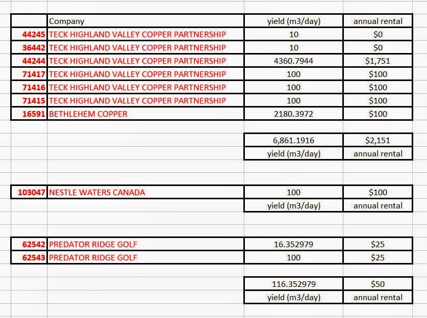
Full disclosure on 'surplus lands' sold by BC Liberals should include Contributions to their Party from the buyers, and Predator (Nestle too) water use paid in pennies

Finance Minister Mike de Jong has promised to have his ministry staff cobble together a full list of 'surplus' land sales to prove that taxpayers weren't hosed on the deals made by the BC Liberals.

A $43,000,000 shortfall being balanced off against an accumulation of totals of smaller winners doesn't  bode well for any forthcoming British Columbia Budgets. 

Mike de Jong says that we should feel good about the fact that 'We broke even'.

In the construction of the spreadsheet by staff may we make a suggestion, add another column, one free from rose coloured glasses:     crystal clear clarity?

With companies owning so many other companies its difficult to know where to draw the line on exactly where contributions originated from and then shifted into the coffers of the governing Party.  

For example:   Wesbild contributions to the BC Liberals

Financial Reports and Political Contributions System

Wesbild Holdings Inc.             

Burke Mountain LLP                

Deep End Holdings                  

Hassan Khosrowshahi            
Predator Ridge Golf Club         

Sweet Apple Holdings             

Westwood Pateau Partnership   


Norman Farrell at Northern Insights/Perceptivity  compilation of 'Hassan Khosrowshahi'  $716,376


If full disclosure is Finance Minister Mike de Jong and his staff's game, then other contributing factors have to be included as well.  A subsidiary of Khosowshahi business empire is possibly in the same league as Nestle Waters Canada and Teck Highland Valley Copper.

From an earlier Post here, Predator Ridge Golf Club water consumption green fees appears as a reflection of other pooled resources eg. Burke Mountain low cost to the buyer, equally low returns for Surplus land to the Province's treasury.
Water, Water almost everywhere in British Columbia, but there is that overwhelming sense of entitlement

Golf Course Greens are in the Black. But is there any Groundwater left for Fracking in the Peace Area?    Is there a business sense of entitlement for Golf Courses?


218  Golf Course owners, combined, of course:

Cubic Metres per Day generates Annual Rent:

87,358 cubic metres per day for $23,183 per year


Monday, April 13, 2015

A show of FORCE: 36 years ago three Destroyers were dispatched to Howe Sound and Malaspina Strait: 4 rail car tankers loaded with Chlorine were missing.

In today's Vancouver Sun (A7) the headline suggests that the oil barons are considering breaking the door down on the moratorium against drilling rigs in local waters for new sources of their petroleum.

The bonus for the environment?  Mary Polak's Press release:  "No ground water will be used."

Oil may lurk below surface of English Bay; testing is planned
Gordon Hoekstra and Tiffany Crawford


With all the kerfuffle over 2,700 litres (17 barrels) of bunker oil contaminating English Bay/Burrard Inlet it was worth a look back over our shoulders for something more tangible than blobs of goo, especially while the Canadian Coast Guard flexed their mighty muscles by bringing in their dive team(s) in zodiacs.

From our distorted memory banks of 40 years ago there was an incident regarding a missing Chlorine tanker that had rolled off the stern of a rail barge between Vancouver and Nanaimo.  In fact it was 36 years and there were two incidents a year apart, both involving the loss of rail tankers loaded with Chlorine destined for pulp mills.  A barge with four rail cars left Squamish for Powell River via the Howe Sound and Malaspina Strait (that's east of Texada Island), they never arrived.  The barge did, but upside Down!

In response to the seriousness of the situation Prime Minister Pierre Trudeau sent the 'Canadian' Navy in three destroyers: MacKenzie, Saskatchewan and the QuAppelle.  Job: do a sweep to find the tankers.   That's a tad more of a show of force than the CCG bringing in dive team(s).

Ellensburg Daily Record 
 February 21, 1975
Search for missing chlorine continuing
The second incident happened on January 31, 1974 just off of Galiano Island where the tanker split apart and drained its chlorine contents into the waters.

 ****************

Find off B.C. may be tanks of chlorine - Globe and Mail - 2004 - Updated 2009

After nearly 30 years of mystery, government scientists believe they have found four rail-car tankers that vanished into coastal waters near Vancouver carrying a lethal load of chlorine.

''We found two blobs that are fairly substantial. They could well be the long-lost rail cars,'' said Robie Macdonald, a research scientist at the Department of Fisheries and Oceans' Institute of Ocean Sciences in Sidney, B.C., who has been on the case of the missing chlorine tanks since they vanished in 1975.

Last month, as part of a long-term program to map the earthquake-prone ocean floor off the B.C. coast, the Canadian Hydrographic Service found something it is calling a "target of interest" deep in the mud of the Malaspina Strait. The finding came after a spate of searches using less-sophisticated equipment failed to find the massive metal tank cars in the late 1970s.  SNIP


Sunday, April 12, 2015

English Bay Spill measured in Litres why not Barrels? 2,700 vs 17 Kinder Morgan's Aframax capacity 750,000 barrels

The Canadian Coast Guard has pegged the English Bay spill at 2,700 litres and took three days and counting to remove what you see, not what you'll eat from the forthcoming fishing industry statistics produced by Ottawa after the next Federal election.

Report on the damage to the Environment by Minister Mary Polak, don't hold your breath.

Kinder Morgan's Aframax and sister crude oil carriers don't count their loads in litres ....... the number would be far too large .... (89,430,353.4 Litres).  Lloyd's call the shots on that and it helps public relation companies paid to promote Kinder Morgan's endeavors bottom line.  750,000 barrels carrying capacity is norm.

As to WHY a senior, second in command, Officer of the Canadian Coast Guard would use litres to explain a spill defies the logic of persons walking in the street or treading in the waters off English Bay.

By way of an explanation, in 1982  Justin Trudeau's father, Pierre, being faced with the price of gas going over a dollar at the pump, and the gas companies pump's rolling numbers only went up to 99 Cents, decided that it was easier, and better able to collect more taxes at that their pump, was to simply convert 99 cents per gallon to 24.42 cents per litre in Metro Vancouver, 28 cent per litre Sicamous.

The gas stations cost to convert?  Applied a Post-It-Note atop of 'GAL'.  Within two years a new electronic version pump was in place right down to eight numbers past the decimal point.

When Minister James Moore was standing at the podium, beating his chest, cheating the local politicians on grandstanding on how efficient the CCG was in handling the spill, he wasn't looking at the metric version of the numbers .....   2,700 litres spotted from aircraft  ....  he chose to look at it as a piddly 17 barrels.


How many litres in a barrel:   158.987295

How many barrels of Bunker Oil was spilled in English Bay:  17

We'll see, hopefully never:

How many barrels of Crude Oil does an Aframax carry:  750,000
(89,430,353.4 Litres)

How many barrels of Crude Oil did the Torrey Canyon carry: 120,000
SS Torrey Canyon
On 28 March 1967, the Fleet Air Arm sent Blackburn Buccaneer planes from RNAS Lossiemouth to drop forty-two 1,000-lb bombs on the ship. Then, the Royal Air Force sent Hawker Hunter jets from RAF Chivenor to drop cans of aviation fuel to make the oil blaze. However, exceptionally high tides put the fire out and it took further bombing runs by Sea Vixens from the RNAS Yeovilton and Buccaneers from the Royal Navy Air Station Brawdy, as well as more RAF Hunters with liquified petroleum jelly to ignite the oil. Attempts to use foam booms to contain the oil slick were ineffectual because of the high sea state. Bombing continued into the next day before Torrey Canyon finally sank.


Some of the oil from the ship was dumped in a quarry on the Chouet headland on Guernsey in the Channel Islands, where it remains to this day. Efforts to rid the island of the oil have continue with limited success.

Designated dumping area for the South coast: Texada Island

Designated dumping area for Douglas Channel: on a 'missing' island in 1,000 square kilometres

However, in this day and age of pristine islands being contaminated, and the technology and zeal to make things right, there is, by way of one recent example the raising, not razing, the Costa Concordia for a mere 750 million Euros.

Living Ocean Report 133 pages
As an Emergency Response training session to a Marine Disaster their capabilities should be started now to recover the Queen of the North.  Oh wait, isn't that mission underway by an American salvage company  to clear the channels for the Aframax entering Douglas Channel via the Inside Passage?


Monday, April 6, 2015

Port Metro Vancouver: At the crossroads: Rail and Marine Tankers at the Second Narrows

Before any Aframax Tankers make their way into the docks at Kinder Morgan's 'Maximize-Me dining area', east of the Second Narrows, there needs to be discussions on the timing of Rail car crossings athwartship, and their ups and downs needs of the Lift Span so as to not impede marine traffic and the Tides.

For Instance:

CN Rail payloads  -  152 cars per train

2003 -  62 crossings of Burrard Inlet via Thornton Tunnel per week
         -  9 crossings per day

2011 - 84 crossings of Burrard Inlet via Thornton Tunnel per week
         - 12 crossings per day

2015 - How many per week N/A
         - How many per day  obviously N/A

2021 - 95 crossings of Burrard Inlet via Thornton Tunnel per week
         - 14 crossings per day

Kinder Morgan Aframax promise: 2018 - 1 per day dependent upon Low Tide

         CNR
Thornton Tunnel North Vancouver Rail Traffic
Page 9 of 18
Weekly Train Movements 2011 - 2021
***********************
As taxpayers have you enjoyed the time and tribulations that are being spent on the deck of the Second Narrows Ironworkers Memorial Bridge?  The 'benefit' is for the safety of cyclists and pedestrian sharing the same space with funding coming from Transportation Minister Todd Stone's budget.  What if .........


 ..... there's a different need for a Ten Foot high spiked top guard rail that is NOT there to stop cyclist and pedestrians jumping from the bridge deck?  What if ....  Kinder Morgan oil tanker owners need to be reassured that objects can NOT be dropped onto their craft from above.

Why then are we paying for security that is Kinder Morgan's responsibility?  NEB?

Over to you Translink!

***********************

Port Metro Vancouver Security video:

 Shows vessels escorting a hypothetical 'Aframax' Tankers during DAYLIGHT hours, only???.  Actually the oil tanker in the video is NOT an 'Maximize-Me' Aframax tanker at all.

The vessel in the video is the Gulf Jumeirah, rated as an MR, NOT Aframax.

               MR                     Aframax
         Gulf Jumeirah        Gulf Vision        Differences (Hint: the Aframax is larger)
                   
               Dimensions        Dimensions       
                   
SDWT      46,488   MT      114,700    MT    68,212
On Draft    12.216    M               15    M            3
TPC           52.26    MT           99.2    MT        47
LOA          183.22    M             249    M          66
Beam             32.2    M            43.8    M          12
Depth            18.8    M                21    M           2
KTM             48.8    M             48.4    M           0
BCM             89.8    M           113.8    M         24
                   
                   
            Tonnages        Tonnages       
                   
GRT      29,508        63,500         33,992
NRT      11,943        19,050           7,107
SCNT    26,605        55,930        29,325
PCNT    24,498        N/A        ?

Great Exercise in PMV flotilla management but the departing Gulf Jumeirah is EMPTY

Gulf Jumeirah Stats


Will the Rail bridge span at the Second Narrows be more up than down during daylight hours for the silent running Aframax and its escort vessels   OR  will the bridge lift span be down at night for the long trains to whistle on through, disturbing the sleep of all those living in the immediate surrounding area?


Wikimapia

In 2013 CNR made the bold announcement that they were removing 'Man' from their Second Narrows Railway Bridge Control Office to operate it remotely from New Westminster....


We took a walk on the wild South side of Burrard Inlet last Fall to escape from the North Shore's heavy industries lining the waterfront east of the Second Narrows.   We chose to use the Trans Canada Trail (TCT)  from Vancouver's New Brighton Park/Pool on McGill.  We meandered through streets of warehouses, a parking lot and eventually made it under the Second Narrows Bridge with seagulls fast tracking down their next meal.


East Side


There was a fork in the trail, one leading up and over the CNR Thornton Tunnel and the other down to the Bridge (to the Left) / Tunnel (to the Right).   There are CNR signs that the TCT is on a Right-of-Way, No Cars Permitted and that the area IS patrolled by the CN Rail Police force.  T/F


We had no intention of accessing the bridge so why would there be a need to call.....


CN Rail security system protecting the service area where Tunnel meets Bridge consists of four motion sensors and a loud hailer.

A 152 hopper car train rolling by negates the well intended purpose of a loud hailer.   

In a country that is multicultural where there are two official languages (two instructions on flight safety in and out of Canada are REQUIRED) where English is no longer the dominant language in Metro Vancouver, CNR uses ENGLISH to communicate.


There's no barrier that comes down blocking pedestrian access, nor is there a chain link fence encapsulating the area.  Security is based on a large dose of Trust!


From the TCT above the Thornton Tunnel there's a clear view of the bridge filmed by enthusiasts of all things related to the movement of rail traffic.

Looking North out of Thornton Tunnel

Looking

Right to the South:

Hopper Cars heading into/out of Thornton Tunnel

*****************************
*****************

Arriving and Departing vessels from Kinder Morgan.....

Burrard Inlet has 8 Anchored Ship positions, swinging on their single bow cables, dependent upon the tide to keep them tethered in an East / West Direction as an Aframax slithers by, so too for the MR.

Translink Seabus service Times 2, crisscrossing North and South every fifteen minutes from Lonsdale Quay and Waterfront Station.

Through the midst of the anchored ships (not including barges, commercial vessels, sea plane, pleasure craft) in Burrard Inlet, the Aframax's Red Line runs through as if it were entering a Kinder Morgan Tank Farm on Burnaby Mountain. Right?

8 anchorages Burrard Inlet


4 anchorages between Kinder Morgan and Cates Park And Indian Arm

3 anchorages east of Lighthouse Park

16 anchorages off Spanish Banks

If you happen to be wondering what the name of those anchored vessels are......

Port Metro Vancouver Anchored Vessels
Interactive Map  highlight an anchorage, name and statistics pops up

Let's not forget about incoming and outgoing normal shipping traffic.

Enthusiast

Caboose Coffee

Note to A.R:  There is no fence protecting the public from danger, just walk on down

Second Narrows Lift Span