Friday, August 31, 2012

"......... where did Grandpa move to after the First World War Da?

Genealogy, sort of......

All this researching through the local libraries, started us thinking about the movement of people caused by religious persecution, pandemics, war, ......itchy feet too...... which then had us staring at

this and directly to this search: Letters from Dieppe.


Your family name, may be in the link above


~~~~~~~~~~~~~~~~~~~~~
Back to Grandpa, and family, in 1913
~~~~~~~~~~
 Poultry Farm Survey
A Report on Sixty-five Commercial Poultry
Farms in the Lower Fraser Valley and
Vancouver Island

By
E. A. LLOYD, B.S.A. Associate Professor of Poultry Husbandry
V. S. ASMUNDSON, B.S.A., M.S.A. Assistant Professor of Poultry Husbandry
R. J., SKELTON, B.S..A. Field Enumerator
Department of Poultry Husbandry, College of
Agriculture, University of British Columbia,
Vancouver

NOTE: Readers, who don't favour the current (2012) Conservative Government spending habits, will like this.....found by looking at a result for a link to the Agricultural Instruction Act, 1913, Canada

 (with two sources provided:  Farmer’s Advocate and the Weekly Sun) Page 3 of 30
In April 1919, the Weekly Sun, published in Toronto, was purchased by the Farmers Publishing Company, renamed the Farmers’ Sun, and declared to be the official organ of the United Farmers of Ontario

Page 1  English and French

In 1913, the Canadian government introduced The Agricultural Instruction Act, a measure which granted ten million dollars to the provinces over ten years to aid agriculture. The Conservatives predicted that the Act would help in “aiding and advancing the farming industry by instruction in agriculture” but this paper argues that, ironically, the funding actually served to heighten rural discontent, not assuage it. By examining public documents and the rural press, the paper explores the rationale, rhetoric, and politics of this initiative. The funding designated for women’s groups is closely examined to determine its impact on the growth of groups like the Women’s Institutes.

"...... where did Grandpa move his family to in Canada?  Did they come to British Columbia?  Were they British or Ukranians?  Were they invited by old Clifford Sifton himself, ..... before the Great War, when he said:
'I think a stalwart peasant in sheepskin coat, born on the soil whose forefathers have been farmers for ten generations, with a stout wife and a half a dozen children, is good quality.'

 Poultry_farm_survey_1921

INTRODUCTION.
In the Lower Fraser Valley and Vancouver Island districts of British Columbia there is a large number of poultry farms. Nearly all of these farms are highly specialized. Over 90% of the revenue from them being derived from the sale of poultry products. Yet the typical poultry farm in British Columbia combines breeding with production of market eggs. For while market eggs are the chief product sold, very few farms can be classed as strictly commercial egg farms on account of the very considerable revenue produced on them from the sale of baby chicks, hatching eggs, and breeding stock.

Since the war there has been a rapid development in poultry farming in certain districts of British  Columbia. Many returned soldiers have taken up poultry farming under the Soldier Settlement Board. More over, many of the older established poultry-men have materially increased their flocks, and a considerable number of other settlers have gone into poultry farming in a specialized way.

Snip

Snip
 page 19 of 19
 (13) The average selling price per' dozen eggs on twenty-nine farms was $0.394, and the average estimated cost of production, including interest on investment at 7% and operator's wages at $80 per month, was $0.456. Wthout allowing operator's wages the cost of production was $0.32 per dozen.

Tuesday, August 14, 2012

Ten Proposed Projects for Kitimat 2005 - 2015 as of July 2011

There's only so much real estate to go to, for these companies, to set up shop in "Kitimat", but at least they're keeping the illustrators busy, and the Canadian Coast Guard as well.    The source for these ten proposed projects for the District of Kitimat is here.  This series of 10, is under the title of Investment Summary on Page 37, and it's from the year of 2010. 

The two previous years, 2009 and 2008, show their projections as well....steadily increasing in value as time is wasted by talking.

If, all ten Projects go ahead, will there be enough space between passing vessels at Hartley Bay?   Will the swells from the passing vessels destroy their aqua crops?

UPDATE: November 6, 2013    Annual Report 2012  Page 34 of 63

Financial Statements (Kitimat (B.C.))

Annual Report
2010
2009
2008

  $2.5Billion  Rio Tinto Alcan Kitimat Modernization Project
A rendering shows what the $3.3 billion dollar Kitimat Modernization Project could look like when completed.


Aluminum, yummy, great location.
~~~~~~~~~~~~~~~~~~~~~~~~~~~~~~~~~~~~~~~~~~~~~~~~~~~
~~~~~~~~~~~~~~~~~~~~~~~~~~~~~~~~~~~~~~~~~~~~~~~~~~
2   $3+ Billion  Kitimat LMLNG Liquefaction and export Terminal at Bish Cove displayed on #4
Apache Canada Ltd., EOG Resources Canada Inc., Encana Corporation
Kitimat LNG is poised to take advantage of Kitimat's many strengths including its strategic location serving the Asia Pacific market. The National Energy Board in Canada has approved KM LNG Operating General Partnership for a license to export liquified natural gase from Kitimat, BC. The company will be allowed to export a total of 200 million tonnes of LNG over 20 years once production at the facility commences.


<-----Sun is setting to the West. Apache/Encana Tank Farm is sitting on shores without any islands running interference.....No Douglas Channel either, looks GREAT!!

 If Northern Gateway #6 below is to the LEFT....how can Apache/Encana be to the RIGHT ????----------------> 

All the tanker traffic, 250 vessels just for Northern Gateway alone, 365 days in a year....

Water doesn't mix with oil.....that's a fact!    

Water and LNG has never been tried!
Therefore, do 320,000 DWT Tankers carrying Enbridge's OIL, mix well with Tankers carrying LNG in close spaces?    Will these tankers only operate in clear weather within our coastline fjords that don't appear to exist in renderings?... with two tugs for each vessel inbound/outbound

~~~~~~~~~~~~~~~~~~~~~~~~~~~~~~~~~~~~~~

3   $1.285 Billion  Pacific Trail Pipeline.  
Where will the pipeline be constructed?
The project consists of an underground pipeline system between the existing Spectra Energy transmission system near Summit Lake and the propose LNG export facility in Kitimat, British Columbia.  The pipeline will be approximately 463 kilometres long.


~~~~~~~~~~~~~~~~~~~~~~~~~~~~~~~
4  Douglas Channel Gas Service Ltd., on behalf of Douglas Channel Energy Partnership, proposes to construct and operate a small-scale natural gas liquefaction facility on the west side of Douglas Channel, south of Moon Bay.   Note: #2 Bish Cove is on the same chart.


~~~~~~~~~~~~~~~~~~~~~~~~~~~~~~~ 
Channel West Partners Ltd ...construction of a Liquified Natural Gas facility at Emsley Cove as seen on the above image.... bottom left hand corner.

Channel West Partners Ltd. is a private Calgary based company engaged in the development of energy related projects in Western Canada. Our initial focus is to target projects which will monetize the abundant natural gas reserves in the Western Canadian Sedimentary Basin.  The management team of Channel West brings a proven track record with expertise in project development, energy trading and marketing, pipeline development, construction and operations, environmental applications and regulatory filings, senior project management of world scale projects financing and financial modelling and First Nation negotiations.
~~~~~~~~~~~~~~~~~~~~~~~~~~~~~~~ 

6    $5.5 Billion Enbridge Northern Gateway marine terminal and pipeline.  And then of course there's "Cheap Charts" to more or less set the records straight.

~~~~~~~~~~~~~~~~~~~~~~~~~~~~~~~  
7    $25 to 30 Million Sandhill Materials Inc. Marine Terminal  and Aggregate export operation. This company is probably hoping to develop their property before the Oil and Gas guys get the thumbs up,eh.


 ~~~~~~~~~~~~~~~~~~~~~~~~~~~~~~~  


 ~~~~~~~~~~~~~~~~~~~~~~~~~~~~~~~  
9   $150 Million Crab/Europa Hydroelectric Project by Ktamaat Renewable Energy Corp.  A run-of-the-river generating facility in the Gardner Canal area.  It would tie into Rio Tinto Alcan's transmission line at Kildala Arm....... talk to BC Hydro about their involvement of another high priced IPP, eh

 ~~~~~~~~~~~~~~~~~~~~~~~~~~~~~~~ 


Friday, August 10, 2012

Cheap Charts for Sale and If Enbridge counted their money the way they don't count our streams, they'd be broke before they started.

Maybe all of Enbridge's statements are loaded with innuendos, needed to be taken with a LARGE grain of salt. For example this straight out approach, via Douglas Channel, from Kitimat to the Pacific Ocean, provided by Enbridge as a reassurance to politicians, in a Video Documentary.

Its an outright lie!!!


You can plainly see that Enbridge removed all of the islands, maybe that's the plan, that Christy Clark has up her sleeve.

Fiction starts at 00:43 UPDATE the link is gone POOF!!
Google Map


Enbridge says that the Northern Gateway pipeline system route transverses many watercourses ....etc


Note:  Watercourse Crossing link has been scrapped by Enbridge website, however a screen shot of their original filing with the NEB is here with the WayBackMachine 2015/01/31
Watercourse Crossings Page 1 of 3

The proposed Northern Gateway pipeline system route traverses many watercourses, from very small brooks to large rivers. Most of the water crossings are technically straightforward and have minimal environmental impacts. The Project has established a strategic watercourse crossings team to conduct detailed site surveys at difficult crossings to ensure they can be built responsibly and with minimal impacts. The pipelines will cross 773 identified watercourses with defined bed and banks; 669 of the crossings are fish-bearing.  SNIP   Source for more Updated 2015/01/31 - NEB 8 page Document
773 Watersheds, does that include Alberta, or just British Columbia?

Does Alberta have fish, or are the 669 crossings of fish-bearing watercourses only in BC?

And, considering how much Alberta has "developed" its Oil and Gas Industry, where they have many, many more inspectors than British Columbia, maybe their watercourses, the brooks and streams, are no more.


The one  two pipelines that Enbridges Northern Gateway Project, which is designed to follow major rivers, with feeders coming in from all directions, should have us on high alert, well beyond AMBER!

Going back to Maps, not the kind that we need to drive, but ones dedicated to expanding our knowledge of our BC Watersheds.........   There's this Map, its actually called an Atlas..........

~~~~~~~~~~~~~~~~~~
First, search for this in Google:         BC Watershed Atlas
~~~~~~~~~~~~~~~~~~
Then click on the section called        Maps - Watershed Code

Which takes you to a               Fisheries Inventory   with instructions on how to use the ATLAS

NOTE:   MOE.... Ministry of Environment.......

  1. Click on the desired MOE Region below. This will display an index map of all the watershed groups within the region.
  2. Click on the desired watershed group. This will display a table of all the WSCA map sheet pdf files within the selected watershed group.
  3. Click on the desired WSCA map sheet pdf file to display the WSCA map sheet image with the 1:50,000 Watershed Codes.
Map   6 is what you want to click on 

Now you're down to a Watershed Group, and the mouth of the Kitimat River where there's this:

KITR

KITR is the mouth of the Kitimat River, where Oil Tankers, 250 of them at 320,000 Gross Tonnes, are going to be fueling up each year and loading up too.

This is the Link for KITR:   Remember, these maps' URL is  FIRST about fish/watershed SECOND
 http://www.env.gov.bc.ca/fish/watershed_atlas_maps/maps/rgn/rgn6tbl.html#kitr

At the top of the table from the link above, there's this:

KITR: Kitimat River  which is whole map for the one Group called KITR

If you zoom in on the above link of KITR, you'll see how each stream, each brook is hemmed in by hills and mountains, like in #27.......24 streams, with feeders to them too, all contributing to our  FISH, our Drinking WATER, our very SURVIVAL.


103i.007 is the mouth of the Kitimat River  ... zoom in to 50%, for a close up look
http://www.env.gov.bc.ca/appsdata/wsca/pdf/r6/kitr/103i_007.pdf

~~~~~~~~~~~~~~
August 11, 2012 UPDATE NOTE

From the map above, the bold blue highlighted numbers are of little use.  What you need to do is get in closer and record the numbers/letters in faint RED, then go back to the previous page select the area that you want to take a more in depth look at.

Enbridge we know about, but Kinder Morgan is continuing on with its goal of doubling up their existing oil pipeline to Burnaby.  Tankers are leaving in greater numbers from the Port of Vancouver because of Kinder Morgan.

Tabular Form by Areas  WSCA Map Library: Watershed Group Maps

CBC interactive map on Pipelines of North America
~~~~~~~~~~~~
More Documentation, lots of documentation
http://ilmbwww.gov.bc.ca/geobc/FWA_doc  FreshWater Atlas Documentation

~~~~~~~~~~~~~~~~~~~~~~~~~~~
~~~~~~~~~~~~~~~~~~~~~~~~
From the above link, the Northern Gateway Project will be crossing THREE Watersheds.  The Peace is to the east of the Canadian Rockies.   Omineca is to the West of the Canadian Rockies, then there is one just called 6, by which the pipeline will be arriving at the mouth of the Kitimat River.

~~~~~~~~~~~~~~~~~~
As a side note......on the topic of  Fish Farms ......like the two Atlantic Salmon fish farms that are being killed off, as we write this,.... our Salmon, our West Coast Salmon, route, is through where the fish farms are.  Our Pacific Salmon are headed for their spawning grounds, via the Fraser River, which has a multitude of Watersheds that feed the Fraser.

An oil spill, would kill everything in its path.

This is the Lower Fraser River.....Do you recognize Richmond, Burnaby, Vancouver, Surrey?  Do you see the brooks, the streams, the rivers......  the USA border with Canada.... Boundary Bay?

LFRA
 LFRA aka Lower Fraser River
 ~~~~~~~~~~~~~~~~~~~~
Map of  Watershed 2, which includes the LFRA

 http://www.env.gov.bc.ca/fish/watershed_atlas_maps/watershed_code/wsg/wsg_r2.htm

~~~~~~~~~~~~~~~~~~~~~~~~


"vessels up to 70,000 DWT, a size easily handled in the naturally deep water found
in the Kitimat Harbour....."   being replaced with 320,000 DWT,
 that's almost five times larger


~~~~~~~~~~~~~~~~~~~
Not only are the Islands missing, so too is Douglas Channel!!!

http://www.northerngateway.ca/project-details/route-video/


Wednesday, August 8, 2012

Land Use Designations in Northern British Columbia and OIL from Enbridge

Maps again, this time its Enbridge's layout of their pipeline without any reference to highways and local roads, no rivers either, nor mountains to tunnel through, and they do, tunnel through two.


Pipeline route


Then there is the Enbridge super-sonic fly-over video from Alberta, to Kitimat, professionally done.


But here we have OUR hand drawn red line edition over top of the "Land Use Designations in Northern British Columbia" version:


1991-05:     Land Use Designations in Northern British Columbia  (updated 2021-02-18)

M.L. Malott, D.V. Lefebure and A. Havard

Open File 1991-05 describes cretaceous and tertiary stratigraphy and industrial minerals in Hat Creek of Southern British Columbia (92I/12, 13, 14). Scale is at 1:800,000.

View Open File 1991-05 (PDF, 615 KB)​

As the Eagle flies

"As the Eagle flies" source Directory.


Watercourse Crossings Page 1 of 3

The proposed Northern Gateway pipeline system route traverses many watercourses, from very small brooks to large rivers. Most of the water crossings are technically straightforward and have minimal environmental impacts. The Project has established a strategic watercourse crossings team to conduct detailed site surveys at difficult crossings to ensure they can be built responsibly and with minimal impacts. The pipelines will cross 773 identified watercourses with defined bed and banks; 669 of the crossings are fish-bearing.  SNIP   Source for more
~~~~~~~~~~~~~~~
Douglas Channel, the to and fro (East and West) means by which the Oil Tankers proceed through British Columbia's Coastal waters is a Recreational area for boaters who are heading North and South, and East and West.

Enbridge is expecting to have 250 Tankers going to and fro between Kitimat and the open waters of our Coastline where none existed before.    As to whether we'll find the Coast Guard setting up a permanent Marine station, anchored, to direct traffic, we'll have to wait till Christy and Stephen sit down for "another talk at the Ice Rink" while the children play hockey.
~~~~~~~~~~~~~~~~

 If you are a resident of Vancouver/North Shore, during the Cruise Ship Season, you'll often hear the toot-toot-toot-toot-toot-toot of the Cruise ships between the hours of 5pm and 6pm, as they leave Burrard Inlet.   The rat-a-tat-tooting is the Cruise ships telling the recreational boaters to get the hell out of the shipping channel.   Fortunately the same doesn't hold true for the Incoming fleet of two Cruise ships in the morning because ...... there's rarely a time when recreational boaters, professional too, are out, and about.   The same holds true for photographers and gawkers.  The best place to be standing is at Stanley Park's Prospect Point where its almost as if you can reach out and touch the passing ship(s).

Fact is, at precisely 6:24 in the morning, you might get a photo like this, and more:

The Island Princess

The Island Princess specifications and its Gross Tonnage: 88,000


Enbridge's Oil Tankers out of Kitimat statistics doesn't mention their Gross Tonnage, but there's a reassuring note from them in one report that says that their  "Vessel speed will be reduced in the marine channels to between 8 and 12 knots".

Then there's the consideration when comparisons are mentioned....by the media on....Tonnage Measurements of Ships.

 As to Enbridge Oil Tankers per se,
Snip
The proponent provided a description of the types of oil tankers that could operate to and from the Kitimat marine terminal. The proponent states that up to 250 large oil tankers will call at its Kitimat facility each year.  Snip

Source for the above via Google using this Search Criteria   Enbridge Gross tonnage of Oil tankers
and the link contains a whole raft of other information as well.

~~~~~~~~~~~~~~~
From a January 8, 2012 Post from the BBC:


 Snip ........ Douglas Channel has currents of only a couple knots and is quite straight. The hazardous places for tankers coming into Kitimat are getting from the open ocean to Douglas Channel....Snip   From Steve Cooley who left a Comment

 The original info above came from another one of those PAGE NOT FOUND of the Vancouver Sun's, but its all here at the BBC.


To put things in perspective, as it was done in the Vancouver Sun article that is no longer available,  a 320,000 Gross Tonnage Oil Tanker, the kind that will be going through Douglas Channel, is equivalent to the vessel being stood up on its Bow...... it would stand taller, than Vancouver's Shangri-La Hotel!

Friday, August 3, 2012

"Doublehs" is code for What? Double Hulls for oil tanker, maybe?

 
is Googleese speech for 


THE DOUBLE HULL ISSUE AND OIL SPILL RISK

www.env.gov.bc.ca/eemp/resources/pdf/double_hull_issue.pdf
File Format: PDF/Adobe Acrobat - Quick View
The double hull issue and oil spill risk on the Pacific west coast. Includes bibliographical references: p. ISBN 0-7726-2472-0. 1. Tankers – Safety measures. 2

Its October 1995, seventeen years away from 2012

SNIP  Page 9 of 54
.....In the wake of the 1989 Exxon Valdez oil spill disaster, a multitude of government studies, workshops and independent reviews recommended double hulls as the single most effective technology to prevent many future oil spills from tankers. Most ship classification societies and legislative bodies accept that total replacement of all existing tankers with double-hulled vessels will result in a 50% reduction in the total amount of oil spilt from tanker casualties.

It is important to realize that double hulled tankers do not mean the end of oil spills; there will always be exceptional accidents such as fires and explosions which result in the loss of oil. Since double hull construction is a design spill prevention measure (not an operational measure), it will not reduce the likelihood of a vessel accident (collision or grounding). Nevertheless, double hulls will result in an appreciable reduction in risk, simply by having a second hull within a hull.

Where are we after years of deliberations about the urgent need to protect our pristine environment?

When will we realize the benefits of new tanker designs? Some 250 million barrels of crude oil and refined petroleum products are moved each year by tankers and barges in Puget Sound, the Juan de Fuca Strait, and British Columbia coastal waterways.

Of this total, over 200 million barrels, or approximately 80% of the total, is still carried in single-hulled vessels.

In essence, “single hull” means that in the event of a collision or grounding there is a single layer of steel, 20 - 35 mm, or about an inch thick, separating the oil cargo and the marine environment.  SNIP 

Page 14 of 54
The map shows the main routes of tankers travelling down the west coast and into the Strait of Georgia/Puget Sound area.

Page 18 of 54
Tanker Design

Page 28 of 54
Tankers, single hull and double hull, resting smack dab on the top of British Columbia's Ripple Rock, past tense, now.

Page 32 of 54
The Province of British Columbia’s Report to the Premier on Oil Transportation and Oil Spills, November 1989 commonly referred to as the “David Anderson Report”, 19 recommended: “ In the event of the Secretary of Transportation (United States) or the National Academy of Sciences (United States) reporting in favour of double bottoms, greater use of ballast sides, or reduced tank sizes for tankers or tank barges, Canada serve notice that within four years such design features will be required for tankers and tank barges calling at Canadian ports”. (Recommendation #20). The National Research Council in Washington recommended in favour of such designs in 1991.

NOTE..... regarding David Anderson, he's the guy who came out this past week, to comment on the current BC Premier's "take" on what's good For BC.   Christy Clark is "missing the point".

Page 39 of 54   (This next 1995 statistic should be taken with a very large grain of SALT)
Future tanker traffic out of Vancouver (primarily Westridge Terminals) is expected to be much less than projected four years ago. Only three vessels sailed in 1994, down from the 12 to 14 loads more typical of the past few years. The trend is towards more “specialty shipments” from Vancouver which could lead to between 6 and 10 tank vessels per year calling to pick-up such cargoes as gas field condensate and synthetic crude.  These cargoes pose less risk to the marine environment than the more persistent crude oils.

Page 40 of 54
Increasing amounts of Alberta crude oil are being moved via pipeline from British Columbia to Washington State. As of November 1994, Canadian crude imports were meeting approximately 20% of the Puget Sound daily refining needs, up from around 1% five years ago. This supply situation is highly desirable from and environmental standpoint as it reduces the overall risk of a marine spill. The pipeline supply is very dependent on pricing and market pressures from other geographic areas.

Page 47 of 54
ACKNOWLEDGMENTS
The following organizations provided invaluable assistance and recent data needed to develop this report: International Maritime Organization, London, England; International Tanker Owners Pollution Federation Limited, London, England; the United States Coast Guard, Washington, D.C.; Trans Mountain Pipelines Limited, Vancouver, B.C.; Seaspan Ltd., Vancouver, B.C.; Washington State Office of Marine Safety, Olympia, Washington; Canadian Coast Guard, Ottawa, Ontario; and British Petroleum, Port of Valdez, Alaska.
This report was produced by DF Dickins Associates Ltd., Salt Spring Island, British Columbia with the assistance of Ann Godon who prepared Part 2 dealing with Tanker Design.


Saturday, July 28, 2012

Enbridge's latest oil spill, today, will probably be a result of plump "Pigs" plugging pipe

 Snipped
.......At about 2:45 p.m. Friday, workers in Enbridge Pipeline’s Control Center detected a pressure drop in the pipeline. Control Center operators (in Edmonton, Alberta) shut down and immediately isolated the line, with a capacity of 317,600 barrels per day, and Enbridge emergency crews were promptly deployed to the site, according to a news release from Enbridge.
Officials moved one person from his home for his safety and comfort, said Lorraine Little, Enbridge spokeswoman........ - Winsconsin Rapid Tribune
 Snipped

 As if Enbridge has had enough problems with oil spills, what next, yes, what next..... one would have to say that maybe its the competition to Enbridge who is just waiting in the wings to take over.  But, can they do a better job than Enbridge....

 Google Search Criteria    are Enbridge oil pipelines double walled

Didn't know why we couldn't access this file earlier today, came up with "404 Error: File Not Found" , but.... along the bottom of the first result was    "ALL 2 Versions".....   one of two didn't fly, note Error message above, but..... the second of two versions worked just fine....     What the BBC was not aware of, was the oil spill, as we researched.

Design and contruction of 42-in liquid pipeline batch pig facilities

R Kratsch - 2008 - gs-press.com.au
... Combined with the Canadian portion of the pipeline system operated by Enbridge Pipelines Inc., the system ... the launcher for launching the pig and for increased draining of the crude oil out of ... Pig signals are positioned upstream of the receiver and on the receiver barrel and to ... - All 2 versions
Link to "All 2 versions" results in this......

Design and contruction of 42-in liquid pipeline batch pig facilities

R Kratsch - gs-press.com.au
ENBRIDGE'S CURRENT major expansion called “Southern Access” is a 42-in liquid crude oil pipeline running 321 miles from Superior, WI to Delavan, WI in 2008 and continuing another133 miles to Flanagan, IL in 2009. As part of the goal to achieve and maintain a high ...

Design and Construction of 42” Liquids Pipeline Batch Pig Facilities

RW Kratsch - 2008 - link.aip.org
Enbridge's current major expansion called “Southern Access” is a 42 liquid crude oil pipeline running 321 miles from Superior, WI to Delavan, WI in 2008 and continuing another 133 miles to Flanagan, IL in 2009. As part of the goal to achieve and maintain a high ...
Enbridge's current major expansion called “Southern Access” is a 42 inch liquid crude oil pipeline running 321 miles from Superior, WI to Delavan, WI in 2008 and continuing another 133 miles to Flanagan, IL in 2009. As part of the goal to achieve and maintain a high quality pipeline system, an automated batch pig system was required to remotely launch the batch pigs, operated from the Control Center in Edmonton, Alberta, Canada...........SNIP

If Enbridge's Control Centre continues to be located in Edmonton, and Kitimat the final destination, most land EAST of the Canadian Rocky Mountains is FLAT, whereas the land WEST of the Canadian Rockies is NOT flat.  Its one thing for the Edmonton Control Centre to note a drop in OIL pressure, with a further "317,600 barrels of oil per day" chomping at the bit, for Eastward bound oil, but what of our position, that is British Columbia, whereby our terrain is far from Flat, and few highways.

Will Enbridge crews gain access to THEIR BC pipeline, if its broken, as easily as it is in the heavily populated, heavily riddled with highways of their eastern laid pipe lines?   eh......

And come to think of it, if its WINTER conditions, well yes, if one waits until daylight Black on White will make it easy to spot, oil spill that is, runs downhill, but just how are Enbridge's response crews suppose to get to the line............

Yes, yes, yes, looking at a map, A paper map, is flat, so too is our computer monitors, looks easy to cross, but have these Enbridge guys, these politicians, these .....advisers to the politicians and oil companies,..... have they ever left their offices, put on gumboots and hip waders to go looking for oil on the loose?

Friday, July 20, 2012

Translink vehicles may use the Lions Gate Bridge, but not "Trucks"

 Truck Route Maps and Regulations   UPDATED: December 2, 2013
Truck Route via City of Vancouver 2013
 Vancouver City Police could be raking in a ton of cash, for the Santa Claus Parade on bikes, in 2014.


************************
"Truck" means a motor vehicle designed or used primarily for the transportation of property.  Page 8 of 92  City of Vancouver  BY-LAW NO. 2849
NOTE: In the link which we have highlighted below in BOLD BLUE   "First Narrow Bridge" via Wikipedia they have written this:  "Trucks exceeding 13 tonnes (14.3 tons) are prohibited"    WHICH isn't true.  NO TRUCKS are permitted because........... read on Dear Readers.

UPDATE:  July 25, 2013

Prohibited vehicles, bicycles and tire chains

9 The following apply to and in respect of the First Narrows Bridge only:
(a) a person must not operate, on any part of the structure or its approaches, a vehicle having a gross weight in excess of 13 000 kg unless the vehicle is a bus as defined in the Motor Vehicle Act;
(b) a person must not operate a bicycle on the roadway of the structure or its approaches;
(c) a person must not operate, on any part of the structure or its approaches, a vehicle equipped with a tire chain or chains.

More and more times we're seeing "trucks" using the First Narrows Bridge, and probably the cause of this sudden influx/outflux is that the drivers, and/or swampers, have a GPS which is telling them that the shortest route between "A" and "B", "downtown Vancouver" and the "North Shore", or visa versus, is via Stanley Park's Causeway, which is true, it is shorter, but.....

There's one catch though, maybe even two catches....... TransLink buses probably outweigh "Trucks" threefold or more in some instances, but the City of Vancouver has determined that although "trucks" may have a lesser GVW than a Bus and the bridges are strong enough to carry both trucks and buses within the allowed GVW per vehicle, they also have right to write a Bylaw, which they did, to designate that the two bridges are NOT Truck Routes.   Passenger cars and cyclists need only apply.

Coast Mountain GVW:
Gross vehicle weight rating – the maximum recommended weight for a vehicle, including: the weight of the vehicle itself, fuel and other fluids, passengers, and all cargo. The manufacturer determines the GVWR. The Motor Vehicle Act Regulations of British Columbia prohibit vehicle operators from loading their vehicle in excess of its GVWR.   - Page 40

For youngsters, once upon a time our beloved Lions Gate Bridge was given a major face lift with the deck replacement, but before that face lift, the bridge had developed a severe "back" strain to its North supporting column..... because of the heavy loads of "trucks" taking the route as their regular route.

That was stopped once the engineers figured out what was going on, or it should have been stopped.

There's a story from ten or eleven years ago where a trucker arrived in downtown Vancouver a half hour ahead of time after coming over from Vancouver Island, where upon he climbed into his sleeper compartment for a nap.   When queried as to why he arrived so early when he shouldn't have arrived EARLY at all..... they discovered he had used the First Narrows Bridge......the Lions Gate, to cross over Burrard Inlet.   OOOOPS!    The Driver should have used the Second Narrows Bridge which would have taken a half hour longer.....and made him on time for his destination.

*****************************************

For Trucks:

Total width no greater than 2.6m(8’6”).
Total height no greater than 3.81m(12’6”) on any street or 4.3m(14’1”)on any truck route.
Total length (inclusive of load and front and rear bumpers) no greater than:
• 12.5m(41’) for a single vehicle.
• 23m(75’3”) for a vehicle with 1 trailer.
• 25m(82’) for a vehicle with 2 trailers.
VEHICLES EXCEEDING ANY OF THESE DIMENSIONS MUST OBTAIN A PERMIT
==================================================

If the Vancouver City Hall wants to earn more cash, and create a safer driving experience for motorists, then there should be fines collected.   In the case of the First Narrows... Lions Gate Bridge, there are options by which over size, TRUCKs, could learn from their experience.... of receiving multiple fines.   Stanley Park Causeway, north bound, is not the end of the road for Truckers, they could take the off ramp just before heading for the bridge deck... and take a tour of Stanley Park...and eventually end up on the Second Narrows Bridge.  If they continue to cross the bridge, then a Two Hundred Dollar Ticket should be enough of a carrot to deter them in the future....   South Bound truck traffic, same story.   No officers required.  All that is required is a system similar to the Port Mann Bridge, and only three lanes need monitoring.

The Ticket, is in the Mail.


Thursday, July 5, 2012

"The media is the surrogate of the public." - Associate Chief Justice Anne MacKenzie


Here at the BBC we know that the Public reads Court decisions, not all decisions, but we have a tendency to keep a close eye on the high profile ones, like the BC Rail Trial which just doesn't want to die.

After the dust settled with the appearance of a BC Liberal buy-out using $6 million of taxpayers monies to secure guilty pleas that killed the BC Rail Trial, the Press went to bat for the public, or did they?

Has the Press been that Mother/Father to the Public, or have they been more interested in what's in it for them and their corporate or political sponsors?

What are we ranting about here today?  Its this closing statement by Associate Chief Justice Judge MacKenzie on June 2, 2011 as to how she views the Public, perhaps how all Judges view the Public, as being cared for by the News Media.

Ruling on Application for Release of Materials                                          [29] The fact the Materials have already been released strongly supports Mr. Krog’s submission that there will be no harm to the administration of justice if they are also released to him. The media is the surrogate of the public. Mr. Krog is a member of the public with a responsible position or role to fulfill. I cannot assume he brings this application in bad faith, or intends to harm the administration of justice. For these reasons, I grant Mr. Krog’s application in the same terms as the February Media Order.

The media has never asked the Associate Chief Justice for the BC Rail Trial, and all things related, just what she meant by  "The media is the surrogate of the public." so they must be in agreement with her thoughts on how the Public is "cared for", lovingly, by  Mother Media and Mother Judges to boot.


Here's a background document for the basis of MacKenzie's "Surrogate Media" people.
 The media is the public’s surrogate, observing and reporting on matters of interest and concern to the public.We’ve all heard it said that justice must not just be done, it must be seen to be done.  -   The Canadian Justice System and the Media

For the Lay Person:

A Google search for surrogate definition

sur·ro·gate/ˈsÉ™rÉ™git/


Noun:
  1. A substitute, esp. a person deputizing for another in a specific role or office.
  2. (in the Christian Church) A bishop's deputy who grants marriage licenses.


surrogate n. 1) a person acting on behalf of another or a substitute, including a woman who gives birth to a baby of a mother who is unable to carry the child. 2) a judge in some states (notably New York) responsible only for probates, estates, and adoptions.


**********************************
One other minor detail regarding MacKenzie's.... "The media is the surrogate of the public."    The Media turned a blind to .......

"...a Mountie decided to treat Bornmann as a witness after admitting to bribing a public official"

Tuesday, June 26, 2012

Bravo Company will conduct a Cordon and Search aka "IAW SoM, B Coy CM1005 IVO Gr 12U QQ 1234 5678."

If you consider yourself to be John/Jane Doe public, have never served in Canada's armed forces, then you won't know what the title of the Post means.

UPDATE: June 27, 2012 These guys would/should know:
Defence Research Establishment-Ottawa (Jun 27 2012 10:34:41am)

Then again if you are John/Jane Doe public, and have read the Province article from June 25, 2012's newspaper (but really written by the Canadian Press) where its called  Easing the soldier to civvy transition subTitle:  "Serving members seek help before being medically released", then you have no right to determine how to ease the soldier into Canada from overseas.

You have no idea what it's like "over there".   Neither do I, but over the weekend, I read a book, and I think I know a little bit more, than you.

Hint:    ISBN Dog tags: 978-1-44340-717-5, Written by Ryan Flavelle.


 SO, HERE YOU HAVE IT.  You are reading the first lines of my first book, the culmination of all my efforts to get a book published.  First of all, I would like to thank you for reading this book ---unless you stole it or are reading the Google Books "preview" -- in which case, go buy my book.  I'm a poor graduate student/reservist.

The title is     "The Patrol",
subTitle is: "Seven Days in the life of a Canadian Soldier in AFGHANISTAN".


Translation of Post Title:
For example, "Bravo Company will conduct a Cordon and Search of suspected compounds near the village of Zangabad" becomes "IAW SoM, B Coy will conduct CM1005 IVO Gr 12U QQ 1234 5678"
It would be easy to provide a link to his book, in Google, but it's even easier to write:  

Stand up, and go to your Local Library!


If you do go to your local library, the authors, illustrators, photographers, publishers, etc. of books in general, receive some compensation, a pittance compared to royalties per book, from the Public Lending Right Commission (Federal)... until Harper gets wind of it.

*********************************

Flavell spent SEVEN months in Afghanistan, fighting.

Tuesday, June 5, 2012

Smart Meter compared to other RF devices like a Baby Monitor, a Cell Phone, a Microwave

Update May 23, 2013 : Link to Bob Mackin's 2010  Gold Rush: 

Smart meter info kept secret until after the election 


Photo UPDATE at the bottom  June 5, 2012   

 Photo UPDATE at the bottom  June 19, 2012   Letter from Curtis Bennett to Enderby City Council

Here's another one of those June 1, 2012 documents that the BC Liberals like to roll out during the Summer Legislative Recess, even though it was created on April 5, 2012.   Its an Amended Report, but what else were you expecting.

 Amended Report on BC Hydro Smart Meter Measurements

 
"Smart Meters will send  brief pulses every 5 minutes (5 minute interval interrogation)"... which means of course that they will be doing it 24/7

Its not clear in this document if the "number" for each device is of equal duration.  All we know is that from the data provided it might be for only of a duration that the Public would normally use their current home devices eg.

When the baby is sleeping (a nap)  teething certainly negates the reason for having a RF Baby Monitor, eh.

Cell Phone, is it sending out a brief pulse 24/7, or only when called upon?

Microwave Oven, Midnight popcorn making, cup of tea for the teetotalers, thawing the chicken for supper.

Smart Meter    brief pulses every 5 minutes (5 minute interval interrogation)


DEVICE

Instantaneous Peak Power Density at 30 cm (Source: Ref. 2)
In units of μW/cm2

RF Baby Monitor      15.6275

Cell Phone                  9.6425

Microwave Oven        7.0775

Smart Meter               4.035


A Smart Meter is on ALL of the TIME

The following is supposed to be BC Hydro's answer to the Public's concerns by comparing their Smart Meter to other devices in our homes... but, but, but.....


Smart meters are designed to emit pulses that last approximately 100 to 150 milliseconds (0.1 to 0.15 seconds) at irregular intervals.

 - In a cluster of smart meters, the meters do not emit simultaneously but are programmed to communicate with a single controller in a random sequence. This mode of operation eliminates the potential for exposure to more than one signal at the same time (Ref.1).

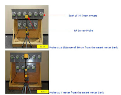
 - In this trial, smart meters were scheduled to emit brief pulses every 5 minutes (5 minute interval interrogation). - The continuous monitoring of RF levels was maintained for a time period of 10 minutes at each position of the probe to ensure that the highest possible RF exposure level was detected and recorded.
Which probably means for condos and apartments where there are BANKS of Smart Meters, the emission of brief pulses communicating with a single controller in a random sequence means that there will be CONSTANT supply of pulses.   Forget the 5 minute intervals!  Its pedal to the metal pulsing.

There is one other detail that wasn't mentioned in their trial of a Smart Meter, and that is each of the Household Devices that were used, are all 110 volts.

Your house, your Apartment, your basement secondary suite, your Condo, have 220Volts running through their "veins".

Do you think that a 110 volt line, normally used to power a lamp stand (in a carpeted room) as a bona fide example, as used in these photos below, ..... would there be enough juice to power TEN Smart Meters let alone even ONE Smart Meter?   In the real world One Smart Meter is supposedly feeding the electricity to the WHOLE house.......


See the singular electric cable coming from the left hand of the display unit which is getting its power from a wall outlet..... which might be fed through a 15 amp breaker!!!!

The point here is why go through the process of mounting 10 Smart Meters on a display wall when all they had to do was mount the "Device" that emits the RF signal on each of the Ten units and record that information.

Is it all about show and not tell?

*********************************

Letter from Curtis Bennett to Enderby City Council

Thermografix Consulting Corporation

June 17, 2012

Enderby City Council
Enderby, B.C.

Att: Chair of Smart Meter Committee – Councillor Earl Shipmaker
cc: Barb Makota, Edgar Murdoch

Re: Questions for BC Hydro on Smart Meter Safety

Dear Councillor Shipmaker;

I was asked to provide information on Smart Meters in my professional capacity as an electrical professional with interprovincial credentials provided by the BC and Canadian Governments.

Smothering Enderby in RF EMFs for ease of communication has serious consequences for the entire community and BC Hydro's presentation for Enderby won't represent them. Power Density is incomplete but alarming language by itself. It means everything the EMFs touch or go through are in the wireless circuit and uninsulated from the frequencies. Power density exists when frequencies create the wireless circuit. Power is watts, volts times amps and all unprotected biological systems have frequencies of their own that were left out of the EMF equation.

Health Canada's Safety Code 6 governs limits of human exposure to wireless frequencies and the predominant health effect to be avoided is the unintentional stimulation of tissue as is the heat effect. Intentional stimulation is medical imaging like an X-ray. When you have X-rays, your body is positioned, protective clothing covers parts of your body for attenuation(elimination) of the frequencies on your side of the clothing. Refusing the protective clothing isn't optional because of the dangers and liabilities.

The highlighted area on Page 19 from the BC Utilities Commission stating they have to comply with Safety Code 6. http://www.thermoguy.com/pdfs/BC-Utilities-Commission-BCH-Smart-Metering-Infrastructure-Program-Business-Case.pdf

The highlighted area on Page 2 in BC Hydro's Fact Sheet states Safety Code 6 is the law and same science standards as the FCC. http://www.thermoguy.com/pdfs/BC-Hydro-RF-Fact-Sheet-Detailed.pdf

Page 9, paragraph 2 of Safety Code 6 admits critical mechanisms are missing linking frequencies to adverse health effects. The weight of evidence approach will be used when mechanisms are found and code will be changed if necessary.
http://www.thermoguy.com/pdfs/Safety_Code_6.pdf

Errors or omissions in Safety Code 6 substantiating the mechanism linking frequencies to adverse health effects were reported to Health Canada and by expert witness at the request of Canadian Parliament's Standing Committee on Health. It was also reported to BC Hydro, BCUC and the BC Government that the frequencies in this application no longer complied with Safety Code 6.

Safety Code 6 admits humans are being electromagnetically induced but negated to include frequencies of ALL electrical considerations, frequencies associated with biological system's function. Humans were treated as Kilograms of tissue being heated by watts. Omnidirectional Smart Meter Routers, tower antennas capable of communicating with thousands of smart devices weren't considered for their interaction with anything including buildings caught in the EMF. You can't blast frequencies around with reckless abandon.

Questions for BC Hydro:

BC Hydro's electrical grid runs at 60 Hz, what happens if the 60 Hz changes? What would happen if the 60 Hz grid was electromagnetically induced? What would the resultant frequency be?
What frequencies of human biological systems did BC Hydro use in frequency interaction considerations.
Location of Smart Meter Routers and how big of an area do they cover.
B.C. Hydro Fact Sheet, page 1 under Proximity states the meter base acts like a reflective shield and further reflects the frequencies away from the resident? The frequencies from Smart Meter Routers and other wireless antennas are hitting buildings from top to bottom communicating with the meter. Can BC Hydro please provide the attenuation coefficients of everything hit by the EMF between the routers, antennas and meter bases holding the Smart Meter? That includes bees, birds, bugs, trees, humans, pets, angles, any biology, any materials of any kind.
The frequencies from the routers are going through building materials, fire separations and hitting anything in their path. Can BC Hydro provide the attenuation coefficients for the building materials including electrical/mechanical systems and the documentation from engineers showing attenuation(elimination) of the frequencies at the building?
Do the frequencies from the Smart Meter Routers, Antennas hit buildings and stop at the meter base or do the frequencies go through buildings? Can BC Hydro provide the required documentation from engineers showing attenuation(elimination)
Can BC Hydro please show documentation the smart meters were tested for accuracy in an EMF under full load of router(4000 smart devices)?
Where is the engineered response from BC Hydro and Minister Coleman on the frequencies going through walls, vibrating structural components causing non compliance with BC Building Code. http://www.thermoguy.com/pdfs/BC-Energy-Minister-on-Wireless-and-Building-Code.pdf
The dangers of wireless frequencies is now lectured in medical academia for education credits doctors need for licensing, did BC Hydro report that to Enderby or other municipalities? http://www.thermoguy.com/pdfs/Medical_Education_Letter_on_Wireless_Lectured_in_Medical_Academia.pdf
The American Academy of Environmental Medicine press release on Smart Meter, was this shared with Enderby? http://www.thermoguy.com/pdfs/AAEM-Resolution.pdf
Did BC Hydro share with Enderby Council, local professionals or constituents the accelerated corrosion information when radiating infrastructure? Refer to Andrew Michrowski.

Frequencies penetrating the body at any depth/angle has serious consequences. Electromagnetic induction of unprotected human electrical grid, causing nerve and muscle stimulation, 180 degree polarization of molecules 1.8 billion times per second at 900 Mhz or twice the frequency. That could break anything including DNA and produces heat not being discussed.

There are serious unanswered questions and a ban on Smart Meter installation is the only option until the weight of evidence is employed as per Safety Code 6. Enderby Council, citizens and Hydro needs to be warned on this very complex issue. This isn't a property dispute, this is a frequency and biological weapon when applied like this. We are not wearing protective clothing to attenuate the frequencies, neither are the buildings. BC Hydro and Health Canada have science to complete and resubmit new calculations. Electrical Engineers don't know frequencies and critical information was left out of an electrical equation.

It isn't insurable to neurologically stimulate populations and Health Canada says that happens but humans weren't considered electrical. Radiating buildings and infrastructure without informing municipal administrators, their science professionals, first responders, education, unions, insurers, pacemaker recipients, health monitoring, medicine, is dangerous.

Sincerely,

Curtis Bennett
Chief Science Officer
Interprovincial Journeyman Electrician(Red Seal)
Engineering Technologist
Adjunct Faculty, IHF & GEDI
Thermografix Consulting Corporation www.thermoguy.com/emfeducation.html