2015-12-29: M=4.7 - 8 km ESE of Sidney, BC
2015-12-16: M=3.4 - 18 km ENE of Ashcroft, BC - felt
2015-11-20: M=3.5 - 181 km NE of Keno, YT
2015-10-31: M=3.3 - 73 km W of Village of Queen Charlotte, BC - felt
2015-10-22: M=4.7 - 204 km W of Port Hardy, BC
I was thinking the sides would continue collapsing to the point where the reservoir would enter the hole - and then the game would be over - BC Hydro's John Baker
The World Trade Centre was safe until an Engineer suggested that the only thing that could bring it down was a fully fueled passenger airliner.
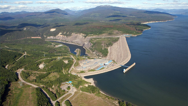
Now we have Engineers for BC Hydro giving the proposed Site C dam, in Northern British Columbia, a "clean bill" of health on safety because it will be able to withstand a 7.6 earthquake.
But what if it were 8.0?
Would the upstream WAC Bennett dam, holding back the flood waters of Williston Reservoir be a prime target for a WTC class passenger airplane, hitting just below the reservoir highest water belt, thereby creating a breach which would send it's 74 km
3 capacity flowing, knocking out the Site C which is rated at 7.6? In essence, an
infamous Domino effect that Christy Clark and her BC Liberals claimed during the 2013 provincial election would never happen to our Economic engine, ELECTRICITY.
Were the instructions by Coleman, and then Bennett, shy when it came to the terms of reference directing BC Hydro Engineers creation of a short list on worst case scenarios? Were they told NOT to include a Tsunami. Tsunamis are associated with the ocean, but even the mighty Mica Dam builders were concerned of a "tsunami" because of a rockface (mountain) directly upstream, was slipping down to the reservoir..... still is... slipping. The Downie Slip: Google Search Criteria:
Mica Dam rock face upstream
Introduction to Coastal Engineering and Management
books.google.ca/books?isbn=9812834850
J. W. Kamphuis - 2010 - Nature
Geologists had discovered that a 1.5 km3 (2 km x 2.7 km x 300 m) rock face was ... the power generating facilities at the Mica dam upstream, which would cause ...
Here's
all the information ever written on the Downie Slide.
The Columbia River Treaty participating
Dams both in Canada and USA (map generated).
*******************
A cubic meter of pure water at four degrees Celsius weighs 1,000 kilograms, or one tonne (a metric ton). The temperature of the water is
significant because the density of water varies with temperature. It is
at its densest at four degrees Celsius.
One thousand kilograms is equivalent to 2,204.6 pounds (lb).
74 km3 = 1000 million tons!
Would the resulting flood cause the Earth to wobble on its axis?
North America .....
Canada ..... data/images
Before the naysayers rise up, the ONLY place that the earthquakes/tremors are happening, inland, in BC, is on a line, running north and south of ......WAC Bennett Dam, Peace River Dam, Proposed Site C Dam!!! Is it the weight of the water....
*****************************************
Google Search Criteria:
WAC Dam Leaking
The Sixty-Story Crisis by Anne Mullens
....... All that is known is that in the middle of the dam, he spied a hole in the asphalt and knew it ought to be reported. The tour guide thought so,too, and called the control building of the G.M. Shrum Generating Station nestled in the east shoulder of the dam.
 |
| SinkHole One and SinkHole Two (out of sight, but not out of mind) |
Unless you’ve seen the Bennett Dam, it is hard to fathom its size. High as a 60-storey building and two kilometres wide, it’s an enormous earth and gravel wedge that holds back 360 kilometres of Williston Lake, the largest reservoir in North America. In a word: massive – and with massive water pressure behind it............
*************************************
B.C. Hydro's sinking credibility: an unexplained 18-foot cavity in the W.A.C. Bennett Dam has already cost $100 million. - Highbeam Business
At stake was the very integrity of the structure and the lives of thousands of people downstream.
Emotions ran high the first few days. Some Hudson's Hope parents, a
mere 15 miles below the headworks, kept their children out of school so
they could make a fast getaway should the worst happen. In addition,
town officials visited an old-persons' home to prepare residents in
case they had to be moved; communities went on alert as far away as
Peace River, Alta., over 200 miles downstream.
***********************************
****************************************
 WAC Bennett Dam
 and Williston Reservoir
 |
| Page 14 of 24 |
*********************************
Looking south, as the Crow flies from the Alberta border to the West:
Alberta to proposed Site C Dam 55km

Alberta to Peace River Dam 114 km

Alberta to WAC Dam 127 km

Alberta to Western most edge of Williston Reservoir 318 km
****************************************
JRP Question B:
If either or both of the upstream dams fail, will the result be the same with and without the Site C dam?
BC Hydro Response: The volume of
Williston Reservoir is about 32 times that of the Site C reservoir. Due to the smaller volume of the Site C reservoir, in the event of a cascading dam failure, there would be small increases in flood levels and flows downstream of Site C. The
volume of Dinosaur Reservoir is about one tenth that of the Site C reservoir. The volume of the Site C reservoir between the maximum normal level and the maximum flood level is about
twice the volume of the Dinosaur Reservoir. Failure of Peace Canyon Dam is very unlikely to result in a failure of Site C due to the large spillway capacity and freeboard. For a failure of Peace Canyon Dam during the probable maximum flood peak flows and water levels downstream of Site C would be fairly similar with and without Site C.
**********************************
As to the Transmission line routes, they go right along The First Nation Heritage trails:
Page 36 of 91
Peace River Site C Hydro Project Heritage Resources Data Gap Analysis
*****************************************
There is now compelling evidence for many gigantic ancient floods where glacial ice dams failed time and again: At the end of the last
glaciation, some 10,000 years ago, giant ice-dammed lakes in Eurasia and
North America repeatedly produced huge floods. In Siberia, rivers
spilled over drainage divides and changed their courses. England’s fate
as an island was sealed by erosion from glacial floods that carved the
English Channel. These were not global deluges as described in the
Genesis story of Noah, but were more focused catastrophic floods taking
place throughout the world. They likely inspired stories like Noah’s in
many cultures, passed down through generations.
By David R. Montgomery|Wednesday, August 29, 2012
*****************************************
Dickinson hopes at least to lay to rest one hypothesis: That an ancient lake carved the canyon through a cascading series of waterfalls. A favored concept for two decades, "I don't think it's a valid story, and my main purpose is to dismantle it," Dickinson said of his new study, published Dec. 13 in the journal Geosphere.
Here's the gist of the idea: A giant lake covering eastern Arizona ate through a limestone ridge called the Kaibab uplift, near the eastern end of the present-day Grand Canyon. A torrent of water spilled through the crack, cutting the canyon we see today. The Colorado River then followed the new course that was set. Becky Oskin, OurAmazingPlanet Staff Writer | December 18, 2012 02:13pm ET -
***********************************
Perhaps Site C Dam should be built between WAC Bennett Dam and Williston main Lake.... topple a mountain or TWO into the ravine.... would leave room for the lake to filter through, and stop the WHOLE of the Lake from draining into
Great Slave Lake.
~~~~~~~~~~~~~~~~~~~~~~~~~~~
Page 13 of 17 Site C dam
The Project would be located at straight line distances of 71 km and 85 km from Peace Canyon Dam and WAC Bennett dams, respectively. The probability of a major earthquake that could produce design level ground motions simultaneously at the Project and one or both of the upstream dams has not been evaluated, but given the distance between these dams, the probability would be significantly lower than 1/10,000
******************************
Index for below locations:
Volume 2 leads to here:
Environmental Assessment Office
Environmental Impact Statement for Site C Clean Energy Project
Eg.
MUST SEE READ Everything you wanted to Know about Site C dam that BC Hydro and BC Liberals refuse to publish......
Volume 2 - Figure 11.2.14 - Map of faults from geologic map of North America (2005) and crustal seismic zones
Red lines Fault Zones Page 1 of 1
Red Stars BC Hydro dams
Index to colours
Bill Bennett is perfectly happy with LNG compression being done with Natural Gas driven turbines
The Project demand for skilled labour during construction would exceed the local labour supply, resulting in an in-migration of workers and a resultant change in local population and demographics. Population change is a determinant of other potential Project effects on housing and on community infrastructure and services. The key indicators for population and demographics are number of persons (gender, age profile, labour force participation), households, and demographic characteristics, including marital status and dependents. Page 1 of 23