Monday, January 26, 2015

Shaky: E&N Railway Bridge Footings

 Model Trains: Clubs Metro Vancouver

 
 **********************

The Real Thing, but.......

Link UPDATE: 2017-08-27    URL to PDF file  579 Pages
Bridge inspection : Southern Railway of Vancouver Island, BC Canada. Phase 1, Inspection report : bridges from Mile 1.30 to Mile 65.10 and 2 bridges on the Wellcox Spur (28 bridges). --

A Report on Vancouver Island's Southern Railway of British Columbia rail infrastructures provides excellent how-to diy drawings for authentic HO Train bridges.  All they need is a copy of that Report or two, one should be enough to raise the concerns of the communities that lie in the path of the real  E&N Railway line.

Two years ago BNSF had their own problems:
Detailed new photos show state of aging BNSF Bridge in South Surrey as potential recipe for disaster.    -  Laila Yuile's No Strings Attached


E&N Assessment Reports    Four held in trust by MoT if you can find them
The Ministry of Transportation and Infrastructure and the Island Corridor Foundation have released a comprehensive assessment of the condition of the 48 bridges and trestles on the E&N rail corridor between Victoria and Courtenay, including two structures on the Wellcox spur between the main line and the Nanaimo harbour. The railway bridge structures range in date of construction between 1906 and 2010. The objectives of the study were to:
  • assess the load carrying capacity of the bridges
  • estimate potential rehabilitation/replacement costs required to the bridges to support rail operations to the end of year 2021, with further estimates of bridge rehabilitation/replacement costs to the years 2031 and 2041.


E & N Railway Bridge Inspections 2011
579 Pages


 Get your scale rulers out:
Page 344 Merged with 345
 
Page 578 and 408 of 579
  
Page 374 of 579
Page 373 of 579
  
Page 550 of 579


Friday, January 23, 2015

Penticton HNZ Topflight's Chief Flying instructor: "If you asked the bighorn sheep, how many generations have been listening to helicopters?"

There has to be something missing in the dialogue between the Vancouver Sun reporter Larry Pynn and the chief flying instructor Tim Simmons for HNZ Topflight: 
Simmons argued that the sheep in Snowy have become accustomed to the training flights over the years and are not stressed as sheep would be experiencing helicopters for the first time. “If you asked the bighorn sheep, how many generations have been listening to helicopters? Much like deer in Penticton, they’re completely used to what they see and hear in their environment.” 

A Conversation overheard between the CFI of HNZ and a bighorn sheep:

Just Asking:

"When did you first stop paying attention to HNZ helicopters?"  Baaaaaa!

"Aha!  Never!"

"How many Generations ago?"


Charles Darwin would probably be amazed that deer Bambi and sheep lambs have made an evolutionary leap frog bypassing youth and arrived fresh from the womb as Rams and Ewes.  How else to explain their having no knowledge of early life stresses involving helicopters.  Blocked it out from butting heads.


The lifespan of bighorn sheep in British Columbia is 14 years.


BC Conservation Status Report pegs their life span as  ........ 18 years, which is equivalent to 3 generations.


The easier way to look at how much helicopters have been pestering the Bighorn sheep is to count the number of years the machines have been in existence, especially by the BC Forest Service fighting fires.
BCFS
72 years ago the helicopter arrive; 14 year life span of bighorn sheep means that there has been Five Generations listening to Helicopters.

In those same 72 years there has been one generation of humans listening to helicopters, second generation for 36 years, third generation for 7 years and if the chief flying instructor were to talk to us we would say that his aircraft does create stress within our communities, why else would YVR have a noise tracker monitors?  Why indeed would there be a Press release this very morning on excessive noise being monitored on either side of Burrard Inlet?

Wednesday, January 21, 2015

Enbridge Northern Gateway 'Discrete Geohazards' outnumber Kinder Morgan Trans Mountain Pipeline ...but

.... but that doesn't mean Kinder Morgan Trans Mountain 'Discrete Geohazards' aka 'Anomaly' or 'Anomalies' pipelines are safer than Enbridge Northern Gateway pipeline.

Enbridge GeoHazard List is longer, much longer in detail than  Kinder Morgan.  Has KM skimped on the details and then claiming immunity .... for reasons of security?  Actually KM only provides the Ten Highest GeoHazards, their number may be much higher than Enbridge's 363 Geohazards.

American Society of Mechanincal Engineers  (ASME): 

Pipeline Integrity Analyses for Construction in Mountainous Areas

ratcheting
Exacerbated by complex routing and profile, pipelines constructed in mountainous areas are at risk to develop significant uplift in the soil at bend locations during hydrostatic testing and initial operating cycles. If such uplift displacement accumulates during subsequent operating cycles, a phenomenon known as ratcheting, the pipe may eventually fail by upheaval buckling. 


 http://proceedings.asmedigitalcollection.asme.org/proceeding.aspx?articleid=2022505


****************

Page 97


One
Two


Three

Four

Five

Six

Seven

Eight

Nine

Ten

Eleven
Twelve

 363 Geohazards

Hoult Creek and Upper Kitimat Valley appear to be the most 'difficult' sections for Enbridge

***************************

Kinder Morgan Trans Mountain 


Page 24

ONE


TWO

THREE

Ferrebeekeeper blogger:Grapefruit: inhibits the activity of a human metabolizing enzyme CYP3A4

CPYP3A4???  I thought Grapefruit needed sugar to sweeten the taste buds.

ferrebeekeeper blogger explains all things nature has created, Man included

Monday's topic was Grapefruit, never the sweetest fruit treat to start the morning off.


I had forgotten the one liner that a London Drugs pharmacist told me to stay away from when taking my meds.  Grapefruit!   Wish I had that as an excuse as a youngster, but then I was independently healthy.

ferrebeekeeper
 The Forbidden Fruit….Grapefruit?


Grapefruit is one of my favorite fruits.  Incongruously I associate the sweet semi-tropical fruit with the most bitter part of winter.  When I was growing up (on a hill farm in central Appalachia), we had crates of the big yellow citruses during winter–an annual gift from some unknown relative.  ......

Snip

..... Grapefruits are healthy fruits filled with vitamins, nutrients, antioxidants, and other possibly wholesome phytochemicals (to say nothing of fiber) however they also contain a chemical which inhibits the activity of a human metabolizing enzyme CYP3A4.  This not-very-euphonically named enzyme allows the liver and the intestine to break down drugs–so grapefruit are potentially dangerous to people taking certain prescription medicines.  According to pharmacologists, more than 40% of drugs can interact with grapefruit!  This sort of thing is why biochemistry is so interesting and challenging!  Maybe there is a rightful reason grapefruit should be called forbidden fruit…but until the doctor actively forbids it, I am going to go have some more…

Skeddadle along to ferrebeekeeper for everything you ever needed to know about Grapefruit and other topics like bees

Friday, January 16, 2015

A Professional photographer like Ansel Adams would have taken one Photo, not 394 and counting, BC Government's


There is a tendency with digital cameras to go overboard in attaining the best photo.  An exception to the rule is the person who didn't use a digital camera, not even a 35mm camera.

One roll of Negative (10), One Photo, One Day


 Ansel Adams 
Photos


--------------------------


Northern British Columbia has it's Wide Open Spaces too and Reports to be written

from notes while backpacking

we certainly wouldn't want to encourage this mode of transportation:


-----------------------------------
The Report:

 Peace Moberly Tract Draft Sustainable Resource Management Plan
Cameron Lake

 Sustainable Resource Plan 84 pages
Cover Photo without Credit given
------------------------------------

Premier Christy Clark has shown the benefits of having slick click happy GCPE staff taking photo after photo after photo.   Keepsakes certainly, but there's always a tendency to blur the lines between Party and Government resources 50/50.    If the photos haven't been looked at for two years, or more, then it's time to turf them.  Surely the people in them have their own copies.

------------------------

In a virtual world Blogger.com will not allow a link to a URL starting with 'ftp://ftp' and they certainly don't allow the jpg file name.  Access a Folder YES.

The only way to capture an image of how the BC Government was 'working' in 2005 is to use the good old fashion method of  Copy and Paste the URL link into a browser and then look for the file number/name in the Directory:

eg.

60CameronLake

ftp://ftp.geobc.gov.bc.ca/.virtual/slk6ftp/pub/outgoing/requests/PMT%20SRMP%20Planning%20Table/PhotosOct25Trip/

And if you're wondering if it's the same photo as above: YES
-------------------------

 eg.

07Cameronlake

Infrared Abstract

ftp://ftp.geobc.gov.bc.ca/.virtual/slk6ftp/pub/outgoing/requests/PMT%20SRMP%20Planning%20Table/PhotosOct25Trip/


YES and Same Directory

-----------------------------------


 Google Search Criteria: PMT SRMP Planning Table/PhotosOct25Trip/


Peace Moberly Tract  Field Trip(s)   (3)

 **********************

93RandallSPLASH

 ftp://ftp.geobc.gov.bc.ca/.virtual/slk6ftp/pub/outgoing/requests/PMT%20SRMP%20Planning%20Table/PhotosOct25Trip/
How Many photos to get the Splash just Right?
YES  same Directory
-----------------------

99BobPassesBob.jpg

 ftp://ftp.geobc.gov.bc.ca/.virtual/slk6ftp/pub/outgoing/requests/PMT%20SRMP%20Planning%20Table/PhotosOct25Trip/
Not Stream Keepers, eh
YES same Directory

**************
Different Department

Virtually

Time to Relax

with 

a

Movie and Popcorn

on 

Government's

Time

Dime


 Cut and Paste URL (updated 2021-12-13)

 ftp://ftp.geobc.gov.bc.ca/.virtual/slk6ftp/pub/ 

The Movie, good, eh


 ************

A helicopter instead of multiple ATVs would have protected the environment, but the purpose of the Report was to satisfy the needs of  BC Hydro Site C project and Oil and Gas companies drilling rigs, and of course the Caribou.  There was an article in the Vancouver Sun this morning on the need to kill 185 wolves because they have been hunting the Caribou which are in limited supply.

**********************

Peace Moberly Tract   Sensitive Areas
  adjacent to Site C 
eg.

 pmt11x17-sensitive.jpg

ftp://ftp.geobc.gov.bc.ca/.virtual/slk6ftp/pub/outgoing/Peace_ Moberly_ Tract/Maps/jpegs/


Trumpter Swan Pairs with Broods, Warbler
-----------------------------------------

eg.

Site C Potential Reservoir in Ten years
-------------------------------

eg.

pmt11x17-tenures.jpg

ftp://ftp.geobc.gov.bc.ca/.virtual/slk6ftp/pub/outgoing/Peace_ Moberly_ Tract/Maps/jpegs/

Tenures Water, Wind, Drilling, Logging, Commercial Recreation
---------------------------------

Hillshade


Saturday, January 3, 2015

BC coastal waters protected by Double Hull tanker ships; CNR, CPR & BNSF rail tankers DOT-111 are 7/16" single hull!

 Isn't it about time to stop the rail carnage by outlawing DOT-111 rail car tankers used by CNR, CPR, and BNSF rail companies?

http://railroaded.wordpress.com/news/

March 12, 2014:

Municipalities Want DOT-111 Rail Tank Cars Banned

Railroaded no exploding oil trains imageA coalition of Canadian and U.S. municipalities has demanded their federal governments ban the single-hulled DOT-111 tank cars that puncture easily and have been involved in a rash of derailments, spills, explosions and fires (Edmonton Journal). The coalition has also asked the 2 governments to force the oil and rail industries to create a multi-billion-dollar fund to pay for cleanups such as the one in Lac-Megantic, Quebec which has been estimated at $1.5 to $2 billion.


DOT-111 tank car?


West of Pemberton; North of Shipyard and Fibreco


A DOT-111 tank car, specification 111A100W1, constructed by fusion welding carbon steel. This car has a capacity of 30,110 US gallons (113,979 L; 25,071.8 imp gal), a test pressure of 100 psi (690 kPa), a tare weight of 65,000 pounds (29,500 kg) and a load limit of 198,000 pounds (89,800 kg).

In rail transport, the U.S. DOT-111 tank car, also known as the CTC-111A in Canada, is a type of unpressurized tank car in common use in North America. Tanks built to this specification must be circular in cross section, with elliptical, formed heads set convex outward. They have a minimum plate thickness of 7⁄16 inch (11.1 mm) and a maximum capacity of 34,500 US gallons (131,000 L; 28,700 imp gal). Tanks may be constructed from carbon steel, aluminum alloy, high alloy steel or nickel plate steel by fusion welding.

Up to 80% of the Canadian fleet and 69% of U.S. rail tank cars are DOT-111 type

Google Search Criteria: DOT 111A100W1


29,000 GALLON TANK CAR
www.gbrx.com/files/files/NAR/Tank_Cars/Tank29000.pdf
M-1002; DOT SPECIFICATION: DOT 111A100W1. THESE GENERAL DIMENSIONS ARE REPRESENTATIVE AND. SUBJECT TO CHANGE WITHOUT NOTICE ...

31809 Gallon Crude Oil Tank Car - American Railcar ...
www.americanrailcar.com/pdf/.../TA-Crude%20Oil.pdf
DOT requirements for transporting light crude oils. – Thermowell. – Sample Line. – Magnetic Gauging ... DOT 111A100W1. Inside Diameter. 122-1/2". Tank Plate ...

Field Guide to Tank Cars - BNSF Hazmat
www.bnsfhazmat.com/refdocs/1326686674.pdf
markings required on tank cars by DOT, TC, and. AAR. ... DOT, TC, and the AAR have established specifications ...... specification DOT-111A100W1 tank car.


West of Pemberton; North of Shipyard and Fibreco


UTLX Basic Designs and Descriptions
www.utlx.com/bdd_tank.html
Basic Design, Shell Full Capacity, DOT Class, Car Type. 10-100-27, 27,200 gallons, 111A100W1, General Purpose Car. 10-100-30, 30,000 gallons ...


Kinder Morgan and Enbridge's pipelines are Single Hull too

Tuesday, December 23, 2014

Barriere BC hasn't changed its name, but Where is Stout's Gulch?

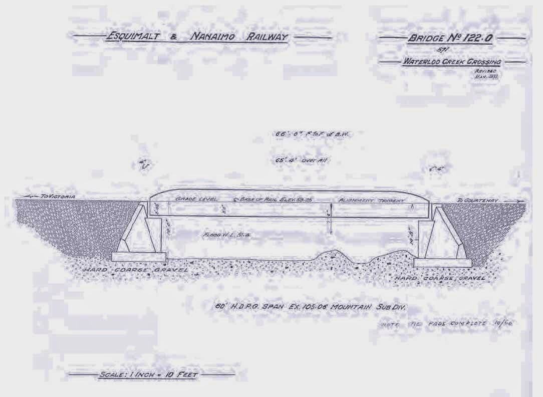
In searching old records we often come across names that we don't recognize, like Eburne aka Marpole.   BC Geo is the site that decipher's old names longitude latitude, like Barriere, BC, which had a gold strike in 1861 on the banks of the North Thompson River.

Once upon a time Deer were more prevalent in British Columbia....... so for today's hunters, here are some old time longitude latitudes.


This document has more to do with Stout's Gulch aka Barkerville...... than Barriere, but the 'theory' of W. H. Mathews is the same for both gold sitings just waiting to be rediscovered.

W. H. Mathews


Lode Gold Deposits sometimes has a file name spelled Load Gold Deposits: eg. South Eastern BC, South Western BC, and Vancouver Island BC.  'Load' will generate three more documents than a search for 'Lode'.

"Drain Lake for Gold" label??? it was!!!
 
Page 4 of 17 listing of gold camps   1948  Load Gold Deposits South Eastern British Columbia

....... Course of veins Compared with Placer Diggings.

Page 24 of 60: In my topographical examination of the country, I could not help observing that, without exception, your extremely rich placers lay immediately below the quartz veins; as, for instance, if we start at the Lord Dufferin claim and follow the croppings passing the old Prospine, now called the California, and continuing along the vein in a north-west course, you will find, immediately below, or at the base of the mountain to our left, runs Williams Creek, which has yielded many million of gold, much of it extremely coarse, intermingled with quartz; while to our right, at the base of the same mountain, runs the Conklin Gulch, which also yielded large quantities of gold, as, indeed, both places are yet doing.

Continuing along the course of the vein and crossing Williams Creek at the canon until the summit going towards Lowhee is reached, we find Stout's Gulch lying to the left and below the vein.  All know how extremely rich that gulch has been, while it is, even now, being hydrauliced far up the mountain side towards the vein.   Following the vein over the summit dividing Stout's Gulch from Lowhee Creek, we find the latter has been rich; and within a very few days samples of heavy gold have been pounded out of quartz found while sluicing.

In the vicinity of the Pinkerton claim the vein crosses Lowhee Creek and pierces the mountain, continuing towards the Jack of Clubs Lake, taking in the Enterprise, now called the "Senator Jones", and extension, "Governor Perkins".

The vein, extending up and through the mountain, no doubt supplied Lowhee Creek with the coarse gold mentioned above; and as the vein crosses through the mountain, the gold found on teh banks of the lake perhaps came from the same source.

I think I shall warn venturesome spirits from attempting to pump the lake out in their anxiety to find gold.

In continuing my survey, I find no source from which the rich diggings of Mosquito Creek derived their gold except from the large, well -defined, and continuous vein and cross veins passing through Island Mountain.  Returning to Lord Dufferin, I was not surprised to find that Grouse Creek could not possibly have received its bounteous supply of gold fro any other source than from the Bonanza vein, where it crosses Grouse Creek as it passes from the California claim and continues through to Lord Dufferin ground towards Antler Creek; and surely no one will question the source whence that creek derived its gold, when not a dollar is being mined above where the vein crosses either the Grouse or Antler Creeks.

I find it impossible to embrace the Burns Mountain in this report; but from observation and information obtained from P. C. Dunlevy, of Soda Creek --- a disinterested person, I think --- I am led to think that the Burns Mountain veins supplied millions mined from Lightning Creek, no gold being found above a point where Mr. Dunlevy supposed the veins crossed the creek.

While I may seem to have been somewhat exhaustive in my report of the above veins, I will say I have been shown samples of ore from what, at present, may be termed outside veins -- notably the Steadman, Sergeant Lindsay, and other veins reaching so far away as Sugar Creek -- and they, without exception, show well-defined walls, and invariably prospect well in gold.  Those on Sugar Creek, however, carry a higher percentage of silver than gold; and beyond doubt, many veins exist not yet discovered.  The country is thickly covered with wees and moss, which makes prospect in or following veins somewhat difficult; but the day is not far distant, in my judgement, when many prospectors will be found busily engaged in uncovering good paying veins.  Some will meet with success, while the dreams of wealth of others will, unhappily, never be realized.  Such is too often the fate of the prospector, which can, in a measure, be palliated by the Government, as I will explain further on.  (See Mineral Survey.)

I must not neglect to account for supposed veins carrying free gold, in some cases lying higher up the mountains than the true veins, which have but little free gold; notably one which was discovered high up -- in fact, on the summit of the mountain above the B. C. mines.

During the glacial period all was chaos.  The irresistible force did not always choose its course and destroy the tops of veins and carry them down to creeks below.  On the contrary, portions of a vein were in some cases detached and carried many miles and landed on some mountain top hundreds of feet height than its original bed, as in the case mentioned.   Instead of being ground and crumbled sufficiently fine to admit of being gradually washed to the creeks below, it was carried in the case of a jam or drift of timber in a swollen stream, where trees may be seen piled up many feet, and beyond the line of the jam.  In such cases the elements have but little effect on the supposed vein, and it lies there undisturbed, while thousands of tons broken ground fine have at the same time been washed to the creeks below. ...................


Mining operation for Gold, Coal, Company

Google Search Criteria for around Barriere
'Open pit, on the northern slopes of Samatosum Mountain, 25 kilometres east of Barriere and 60 kilometres north of Kamloops (Friesen, 1990).

 *****************

And, if you're the least bit curious about that there deserted road bed which appears to be a dead end, whether you're there in person, or looking on a map, or in Google Earth, or BC Geo, just pop the longitude latitude coordinates into the programs to find what's nearby, 5, 10, 15 kilometer radius,
from this here novice starter spreadsheet:

Excel Table of Historic Mines


eg.  Drilling Resumes on the Mucho Oro Zone - Barkerville Gold ... Stouts Gulch


*******************

This document shows Iceflow routes throughout BC.... which if it's true that GOLD deposits have been hopping from a low hill to the top an adjacent mountain then why not build a database on where that's happened eh.... to find another Barkerville 


Soil Landscapes of British Columbia Page 49 of 196

Kootenay Lake is REALLY deep which means the Mount Polley dam busters deposits will go DEEP too.